


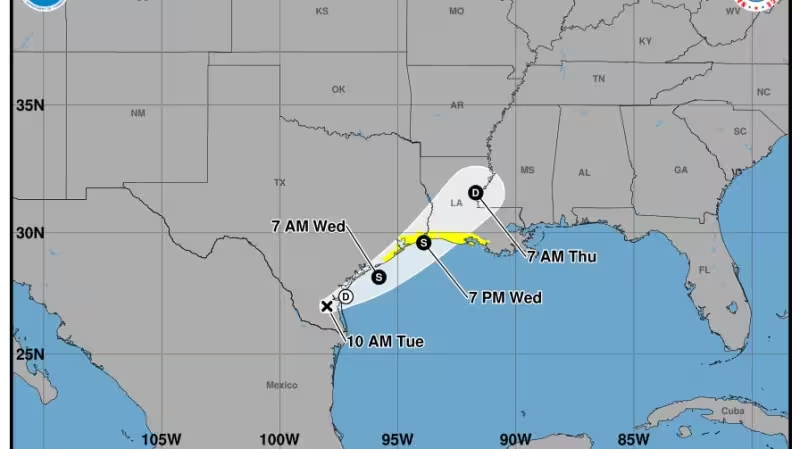
Forecasters said on Tuesday, June 16 that the first named storm of the 2026 Atlantic hurricane season could form in the Gulf of Mexico within the next day or two, with a window for development running into Wednesday, June 17.
AccuWeather hurricane expert Alex DaSilva gave the short window directly: "The time frame for possible development is from Tuesday [June 16] to Wednesday [June 17] before the system moves inland," and the National Hurricane Center put the chance the system would reach Tropical Storm Arthur at about 60 percent as it moved into the Gulf.
The stakes are rainfall and flooding. The National Hurricane Center warned that interests across southern and eastern Texas and portions of Louisiana and Mississippi should prepare for periods of intense rainfall over the next several days, saying the rain could produce widespread, life‑threatening flash, urban, and river flooding. Radar showed that parts of east‑central Texas and central Louisiana had already received 5 to 8 inches of rain since Sunday, June 14.
The scale of the threat is underscored by forecasts that an additional 10 inches or more could fall locally across areas of the Deep South this week and by the Weather Prediction Center’s moderate risk of excessive rainfall through early Friday for portions of southeastern Texas, Louisiana, and central Mississippi and Alabama.
How the system is handled in public messages will matter. Tropical storms earn a name when forecasters describe an organized system with a warm central core and maximum sustained winds of at least 39 mph; that threshold is why the phrase tropical storm watch appears in briefings as forecasters weigh whether the circulation will reach named‑storm strength before landfall.
There is a friction here: the system carried only a 60 percent chance of becoming Tropical Storm Arthur as it entered the Gulf, yet the National Hurricane Center still warned of life‑threatening flooding whether the system ever reached that name. That split — modest odds of naming but clear danger from heavy rain — is the practical risk residents face.
Hurricane specialist Michael Lowry of WPLG‑TV in Miami summarized the expected impact in plain terms: the primary weather effect across the Texas Gulf Coast and the Lower Mississippi River Valley this week would be widespread, heavy rainfall and flooding. Gusty winds and coastal flooding were also possible along portions of the northwestern Gulf Coast, the hurricane center added.
The warning extends beyond coastal counties. The Weather Prediction Center’s moderate risk area centers on places already hard hit by recent rain, and forecasters are asking emergency managers and the public to plan for several days of high water on streets and rivers. The National Weather Service notes that more than 50 percent of flash‑flood deaths happen in vehicles driven into floodwaters — a reminder that most flood fatalities are avoidable.
Practical preparations this week should focus on the flooding threat rather than the storm’s name: moving valuables from basements, monitoring river gauges where available, and avoiding drives through flooded roadways. Forecasters said the system is expected to move inland after the development window, but it is not certain whether it will reach named‑storm strength before doing so.
What to watch next: whether the system consolidates a warm core and 39 mph sustained winds while over the Gulf during the Tuesday–Wednesday window, and how much rain falls as the circulation slows or pushes inland. The unanswered, decisive question is not simply whether Arthur will be named — it is whether the system strengthens before landfall or instead floods inland areas without ever becoming a classic tropical storm. Communities from southern Texas through parts of Louisiana and Mississippi should plan for the latter possibility as the immediate threat.


