


How an iPhone Satellite Feature Helped Rescue Efforts After tahoe avalanche
Six survivors of a deadly backcountry slide near Lake Tahoe were able to communicate with rescuers using an iPhone’s Emergency SOS satellite feature and an emergency beacon, helping coordinate a multi-hour response in terrain with no cellular service. Officials are investigating the decisions that led the guided party into high-risk conditions ahead of the storm.
How the satellite Emergency SOS worked in the field
When standard voice or data connections are unavailable, the Emergency SOS feature on modern iPhones can route a text message to emergency services satellite. The group used that capability and a traditional emergency locator beacon to relay critical information to the Nevada County Sheriff’s Office while rescues were being coordinated. Don O’Keefe, the law enforcement chief for the state Office of Emergency Services, said one member of his team maintained a four-hour exchange with a guide on site to relay updates and evaluate what rescues could be attempted.
The feature is designed for use outdoors with a clear view of the sky and horizon so a phone can reach overhead satellites. Users are instructed to attempt an emergency call first; if that fails, the phone will guide them to send a satellite text to emergency responders, who then request details such as location, emergency contacts and remaining battery life. All models of the iPhone 14, 15, 16 and 17 support the function, with the service enabled on devices running iOS 16. 1 or later. Emergency SOS satellite is provided free for the first two years after activation. Certain Android devices also offer comparable satellite emergency text capabilities on supported models.
Warnings, the guided trip and unanswered questions
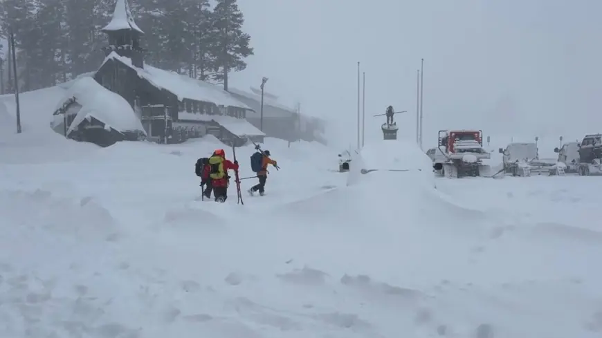
The slide struck a group that had departed for a multi-day guided outing to remote huts at Frog Lake. The region had been bracing for a major winter storm that meteorologists warned could drop several feet of new snow and create unstable avalanche conditions. A regional avalanche center issued a watch shortly before the party set out, noting the potential for widespread avalanche activity and cautions against travel in or beneath avalanche terrain during a period of HIGH danger. The watch was posted at 7: 45 a. m. ET on the day the group departed.
Despite posted warnings and public advisories that the Frog Lake area is uncontrolled avalanche terrain requiring appropriate education and equipment, the guided party went ahead. The slide killed three guides and five guests and left six survivors; one person has not been found and is presumed dead. The guiding company is under scrutiny and authorities have said investigators will examine the full circumstances of the trip, including why it was not canceled given the forecast and avalanche watch.
Rescue challenges and what comes next
Rescuers faced layered challenges: deep new snow, unstable slopes, and limited access in a remote basin. The satellite text exchanges provided situational awareness that helped prioritize search efforts and preserve resources while teams assessed safe windows to attempt recovery operations. Officials have said crews will wait for safer conditions to remove the deceased and continue the investigation into operational decisions made by the guiding service and the group leaders.
The episode underscores two broader points for backcountry travelers: the life-saving value of redundant emergency communications and the gravity of heeding avalanche watches and forecasts. Emergency beacons and satellite messaging can sustain contact when cell service is absent, but they do not reduce the inherent risks of traveling in high avalanche danger. Authorities and local land stewards reiterate that winter wilderness travel demands formal avalanche training, proper equipment and conservative decision-making when forecasts indicate rapidly changing, dangerous conditions.