


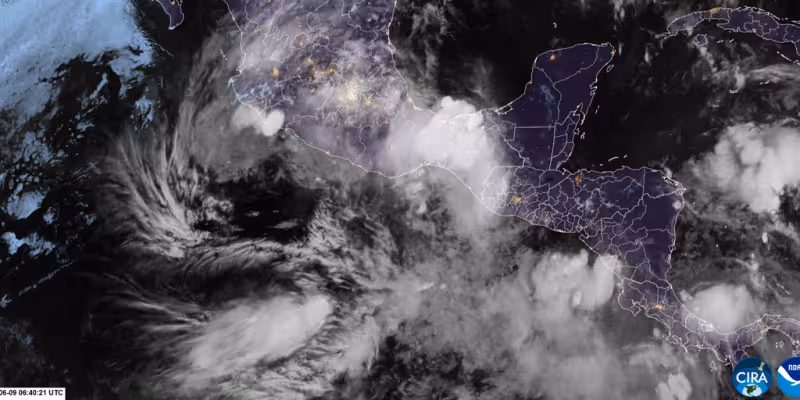
Tropical Storm Cristina formed Monday afternoon just off Nicaragua's Pacific coast and was crawling toward a Central America landfall on Tuesday, prompting tropical storm warnings for the coast of El Salvador and northwest Nicaragua into early Thursday. The storm had maximum sustained winds of 40 mph and was centered about 100 miles south-southeast of San Salvador, El Salvador, moving west at 3 mph.
The National Hurricane Center warned Cristina could bring heavy rain and life‑threatening flash flooding to Nicaragua, Honduras, El Salvador and Guatemala through midweek. Forecasters expected widespread rainfall totals of 4 to 8 inches, with localized amounts up to 12 inches in the most threatened areas. Over 6 inches could fall in parts of El Salvador, far northwest Nicaragua and possibly in parts of southern Guatemala.
Tropical storm warnings issued along the Central American Pacific coast cover communities that will see the first and heaviest rain. Forecast maps, including products from Accuweather, showed the slow westward crawl keeping the storm's bands over coastal and nearby inland areas for an extended period, increasing the risk that torrential downpours will produce flash floods and landslides.
The timing and intensity on the coast are sharp: Cristina is expected to move inland and weaken on Thursday and fizzle after landfall in El Salvador by sometime Thursday. Still, the immediate danger is not wind but water — the combination of heavy rainfall totals and the storm's slow motion raises the risk of rapidly rising rivers, blocked drainage and hillside failures in mountainous coastal zones.
Jonathan Erdman, who has covered national and international weather since 1996, warned that the storm's rainfall could be the greatest hazard. Erdman said the setup "could trigger life‑threatening flash flooding and landslides, especially in hilly or mountainous locations near the coast." Those are precisely the areas where soil saturation from sustained downpours produces the most destructive sudden flooding.
The slow 3 mph westward movement is the friction point in the forecast. Cristina is expected to weaken quickly after landfall, but its crawl toward shore lengthens the window for heavy precipitation to fall over the same river basins and slopes. That pattern increases flooding potential before the storm loses tropical characteristics, even as its maximum winds remain near tropical storm strength.
Cristina follows a brief run of early Pacific activity: Tropical Storm Boris became a named storm early Monday with 40 mph winds before weakening as it moved ashore later that evening and officially dissipating over southern Mexico on Tuesday. Cristina formed Monday afternoon and is now the immediate operational concern for Central American coastal communities.
Emergency managers and residents along the Pacific coasts of El Salvador and northwest Nicaragua should expect persistent heavy rain through midweek while tropical storm warnings remain in effect into early Thursday. The most consequential unknown is how far inland the worst of the rains will penetrate before Cristina breaks apart; that detail will determine whether damage is confined to coastal and adjacent hillside communities or extends deeper into populated valleys.


