


Kcrg First Alert: Winter Storm Warning Prompts School Delays, Slick Overnight Travel and 6–9 Inches Possible
kcrg warns of hazardous travel overnight through Friday morning as a mix of rain and snow transitions to all snow across eastern Iowa, prompting school delays and cancellations amid a winter storm warning. Motorists should expect slick roads, reduced visibility and the potential for a heavy band of snow that could dramatically change local accumulations.
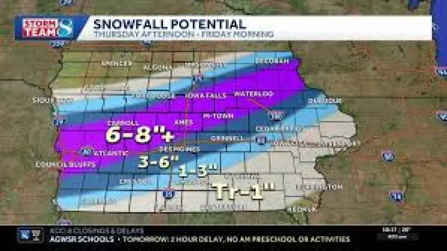
Kcrg First Alert — Timeline and snowfall details
The transition from rain to all snow will push eastward overnight. The changeover is expected to reach a line from Manchester to Cedar Rapids to Iowa City between 10 PM and midnight, then move toward the Mississippi River between midnight and 2 AM. Snow will continue through the overnight hours, with far western counties seeing the snow end between 5 and 7 AM Friday. From there, snowfall will taper from southwest to northeast, and by noon the snow should have crossed the Mississippi River and moved out of the area.
Forecast guidance highlights a fairly confident expectation that a heavy band of snow will set up across eastern Iowa, producing 6 to 9 inches of accumulation in that axis. There is the potential for a sharp cutoff in totals to the north and south of this band, meaning small shifts in the storm track could produce significant differences in local snowfall amounts. The axis of heaviest snowfall is expected along a line from Waterloo to Fayette to Prairie Du Chien.
Impacts, travel advice and school decisions
Plan on slick travel overnight through Friday morning, especially where the heaviest snow falls. Winds will become gusty overnight and remain strong on Friday, increasing the chance of blowing and drifting snow and further reducing visibility. Because road conditions can change quickly, extra travel time and caution are essential for anyone who must be on the roads during the storm window.
Schools are delaying or canceling Friday classes amid the winter storm warning. Families and commuters should monitor local decisions and prioritize safety when choosing whether to travel.
Practical precautions for drivers include allowing plenty of following and stopping distance, leaving extra time for trips, and carrying emergency supplies such as food, water, a flashlight and a blanket. These steps are particularly important if traveling through areas expected to receive the heaviest snowfall or where winds may cause drifting.
Temperatures, weekend outlook and what follows
Highs on Friday will range from the mid 20s in northern counties to the low to mid 30s south of Interstate 80. Friday night lows are expected to fall into the low to mid teens across the area, with those under a thick, fresh snowpack potentially dropping into the single digits.
The weekend forecast calls for mostly cloudy skies on Saturday and partly cloudy skies on Sunday. Highs are expected in the mid 20s to low 30s with overnight lows in the teens. After a cold Monday with partly cloudy skies and highs in the upper 20s to low 30s, temperatures are expected to rebound into the mid 40s for highs through the middle of next week while lows hold in the 20s and 30s and the weather remains quiet.
Key takeaways
- kcrg emphasizes hazardous overnight travel through Friday morning as rain changes to snow across eastern Iowa.
- A heavy snow band capable of producing 6–9 inches is likely across eastern Iowa, with a sharp cutoff possible north and south of the band.
- Expect gusty winds, blowing and drifting snow, and reduced visibility; plan travel carefully and heed local school decisions.
Details may evolve as the system progresses; motorists and families should stay alert to updates and prioritize safety during the overnight and Friday morning period.