


Philadelphia Weather: Boom or bust? What to know about possible snow this weekend
The latest Philadelphia Weather update centers on a developing coastal system that could bring precipitation to the region midday Sunday and last into Monday. Why it matters: models still disagree sharply on strength and track, producing outcomes that range from a light, wet snow to a heavy, wind-driven storm with coastal impacts.
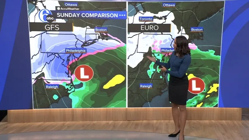
Philadelphia Weather: Two scenarios and the odds
Forecast guidance currently presents two primary scenarios for the Delaware Valley, each with different odds and impacts:
- Weaker, offshore track (most likely). A flatter storm moving farther offshore is the favored outcome, carrying about a 70% chance. This scenario would most likely produce a light, wet snow across the area, with the possibility of a localized band of heavier snowfall where an inverted trough sets up.
- Stronger, near-coast track (less likely). A stronger low tracking closer to shore is currently given roughly a 30% chance. If that verifies, parts of the region could see over a foot of heavy, wet snow with wind gusts near 50 mph and the potential for blizzard-like conditions in exposed areas.
Additional numerical guidance for the immediate Philadelphia region notes a high overall chance of precipitation (around 80%), a roughly 60% likelihood of at least two inches of snow, and about a 30% shot at six inches or more. Forecasters emphasize the wide margin of uncertainty: small shifts in strength or track would markedly change snowfall totals and impacts.
Timing, impacts and commute risks (ET)
Timing across guidance is relatively consistent that precipitation will arrive Sunday and linger into Monday. Descriptions of arrival vary from midday Sunday to late Sunday morning or afternoon, with some guidance indicating precipitation may continue overnight into Monday. Temperatures are expected to tumble into the 30s during the precipitation window, which will influence the rain-versus-snow line and accumulation potential.
Impacts to watch for:
- Roads and travel: a potentially dangerous commute is possible during the evening and into Monday morning if heavier snow and wind materialize.
- Coastal threats: a potent coastal low could bring coastal flooding and strong onshore winds if it tracks close enough to the coastline.
- Ice: current guidance indicates no ice is expected for this event.
Before the storm window, a mild stretch with temperatures in the 40s and a sunny Saturday near the 50s is expected to help reduce existing snowpack in many areas.
What to watch next for Philadelphia Weather
The key elements that will determine whether this event becomes a routine snow or a major storm are the storm's final strength, how close it tracks to the coast, and the timing of its development offshore. Forecast models will continue to be refined over the next 24–48 hours as the system organizes farther west. Residents and local decision-makers should monitor updates for changes to track, snowfall projections, wind forecasts, and coastal flood potential.
Because model guidance still presents a wide range of possible outcomes, expect evolving forecasts and adjustments to watches, warnings, and impact messaging as the system approaches. Details may change as new data arrives.