


Winter Weather Advisory Issued as Quick-Hitting Snowstorm Targets Southern Maine Friday Evening
A Winter Weather Advisory is in effect as a fast-moving system from the Great Lakes brings plowable, at times heavy, snow to southern Maine and nearby New Hampshire from Friday evening into Saturday.
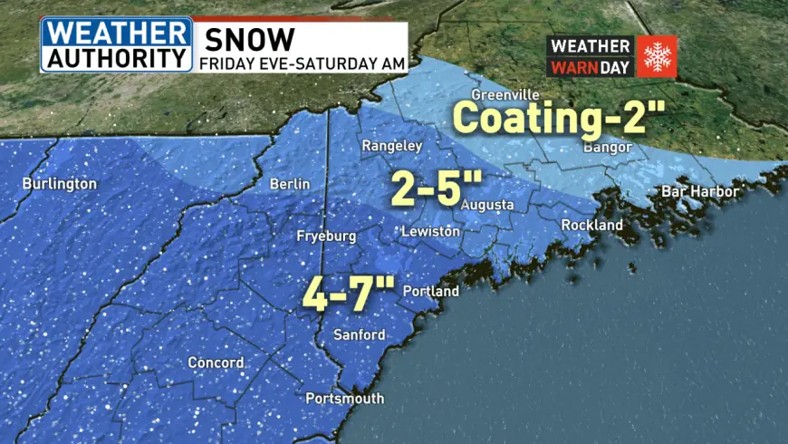
Winter Weather Advisory: where it applies and the official timing
Winter storm warnings are in place for interior York County and much of southern and central New Hampshire from noon Friday ET through 7 a. m. Saturday ET. Winter Weather Advisory designations cover additional areas from 6 p. m. Friday ET through 7 a. m. Saturday ET, where accumulating snow and travel delays are expected.
Snow is forecast to begin between 4–6 p. m. Friday ET in the southwest corner of the state and spread across much of the region. By around 9 p. m. ET snowfall is expected to be steady across large swaths of the state. After midnight ET the snow should start to taper, leaving lighter, scattered snow showers through daybreak Saturday ET.
Snow totals, timing and travel impacts
The system is expected to produce several inches in many places. Forecast totals call for roughly 4–7 inches across the majority of New Hampshire and southern Maine, including areas around Sebago Lake, York and Cumberland Counties and southern Oxford County. Midcoast Maine and corridors through Lewiston and Augusta into Rangeley are expected to see about 2–5 inches. Points north of those areas may receive a coating to 2 inches, while extreme northern sections are expected to remain dry.
With coastal temperatures near or above freezing, the snow along the shore is expected to be wetter than earlier in the season. That wetter snow, combined with the forecast timing of the heaviest bands Friday evening, will make travel slick. Motorists should anticipate deteriorating conditions Friday afternoon and evening, and the potential for slick roads Saturday morning, though plows are expected to have time overnight to treat and clear primary routes.
What to expect during the event
This is a quick-hitting storm driven by a system developing over the Great Lakes. Snowfall could be heavy at times, particularly for southern Maine where darker shades of heavier precipitation are indicated in the forecast. The most intense period is expected from the evening into late night Friday ET, easing after midnight ET into lighter showers by daybreak Saturday ET.
Communities in the advisory and warning areas should prepare for accumulating snow and possible travel delays. The timing, the wetter coastal snow, and the heavier bands across southern Maine and much of New Hampshire are the primary developments to watch as the storm arrives Friday evening into Saturday.