


A confirmed large and extremely dangerous tornado moved through northwestern Indiana on Wednesday evening, and weather spotters had already put it on the ground as forecasters issued a Particularly Dangerous Situation Tornado Warning. At 8:32 p.m. CDT, the tornado was over Wanatah, about 7 miles southeast of Westville, and moving northeast at 35 mph.
The warning covered La Porte, Westville, Kingsford Heights, Wanatah, Hamlet, Hanna, Kingsbury and Thomaston, with residents told to get into a basement or an interior room on the lowest floor of a sturdy building and stay away from windows. The National Weather Service said the storm could bring catastrophic damage, deadly flying debris, destruction of mobile homes, considerable damage to homes, businesses and vehicles, and even complete destruction in its path.

That combination of a confirmed tornado and the language of the warning underscored how quickly the threat escalated for communities in northwest Indiana. The storm was not just capable of producing damage; it was already producing it, and forecasters were warning that anyone outside shelter could be hit by debris with little margin for error.
The same severe weather system was causing trouble elsewhere on Wednesday. A confirmed tornado tore through Streator, Illinois, where Illinois Route 18 entering the city was closed because of storm damage and hazardous conditions, while severe storms produced 75 mph gusts in Mason City, Illinois, 72 mph gusts in Ames, Iowa, and Lower Burrell, Pennsylvania, and 70 mph gusts in Chestnut, Lewistown and East Peoria, Illinois. Washington, D.C., Arlington and Alexandria, Virginia, were also under a Severe Thunderstorm Warning through 8:30 p.m. EDT.
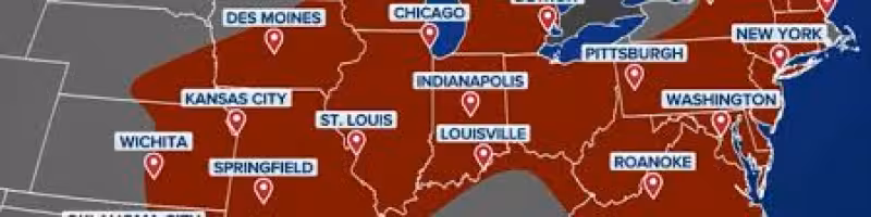
The broader pattern spread damaging winds, large hail and multiple tornado warnings across the Midwest and Mid-Atlantic on Wednesday, with roughly 6.2 million people facing strong thunderstorms capable of pea-sized hail and wind gusts up to 60 mph. For northwest Indiana, the unanswered question is how much damage the tornado left behind as it moved through the warning area and whether additional communities would be forced to deal with the aftermath after dark.


