


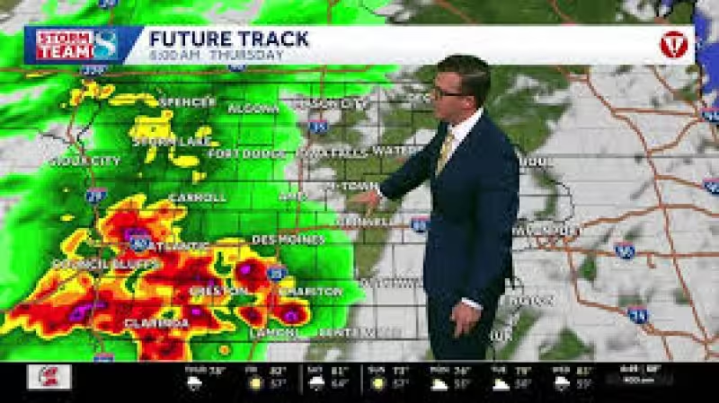
A Thunderstorm Watch remained in effect for portions of the TV9 viewing area until 10:00 a.m. as strong to severe storms pushed through central Iowa this morning. The biggest concern early was damaging wind and large hail, though an isolated tornado could still develop as the storms strengthened and moved east.
Much of the area was in an Enhanced Risk for severe storms, while nearly all of the rest was in a slight risk, underscoring that the morning commute sat inside the most active part of the day. A line of severe storms was expected to track across the state near and just after daybreak, with the most likely window running from about 7:00 a.m. in western communities to 11:00 a.m. in the east.
That timing matters because the first round was already developing in central Iowa and could reach different parts of the viewing area while people were heading to work and school. The threat was not the same everywhere at the same time: western communities faced the earliest impacts, while eastern communities were more likely to see the storms later in the morning.

Forecasters also were watching a second window between about 1:00 p.m. and 6:00 p.m., when scattered storms could form near and ahead of another cold front. That afternoon setup carried the same severe hazards — large hail, damaging winds and tornadoes — but the balance of threats could shift depending on how the storms organized. If they stayed individual, the tornado risk would stay higher. If they packed into lines, damaging winds would become the bigger concern.
The setup leaves one clear takeaway for the rest of the day: the morning threat was only the first round. Drier air was expected to move in after the activity, with lows Thursday night falling into the upper 50s and Friday turning much drier with highs around 80. But before that calmer air arrives, the state still has to get through two separate chances for severe weather, and the afternoon round may decide whether wind or tornadoes become the more serious threat.
After Friday’s brief break, Saturday brings another chance for showers and storms, especially in the afternoon and evening, before Sunday turns cooler and drier again with highs in the low 70s. There are also a couple of slim chances for a shower or storm Monday into Tuesday, followed by a gradual warm-up late in the 9-day forecast.


