


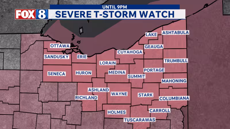
A 19 First Alert Weather Day is in effect for Cleveland and all of Northeast Ohio as severe storms are possible this afternoon and early evening. The main threat is damaging wind gusts and heavy rainfall, with large hail and even a brief tornado also possible before the local severe-weather risk ends no later than 7 p.m.
Showers and storms are expected to start near the western lakeshore around 2 p.m. and then move south and east through the region, even though the Severe Thunderstorm Watch remains in effect until 9 p.m. The practical window for the worst weather is shorter: after 7 p.m., only a few light showers are expected, and temperatures should fall into the 60s as winds shift from southwest to northwest at 10 to 20 mph.
That timing matters because the watch covers the whole region, but the stronger storms are expected to clear out before the watch expires. The setup leaves Northeast Ohio with a narrow afternoon-to-early-evening window for the most disruptive weather, which is when the potential for wind damage, flooding rain and isolated hail will be greatest.

Once the line moves through, Sunday night turns quieter. Low temperatures are expected to drop into the 50s overnight, and Monday is forecast to be dry under a partly cloudy sky with a high around 70 degrees. Tuesday should stay dry as well, with sunshine and highs in the mid 70s.
The next round of unsettled weather arrives later in the week. A few showers are likely late Tuesday night into early Wednesday morning, then much of Wednesday is expected to be dry with a mix of clouds and sun before showers and storms return Wednesday night into Thursday morning as another system approaches. A couple severe storms are possible then, and another 19 First Alert Weather Day is already in place for Thursday.
For now, the question is not whether the region gets another weather headline this week; it is whether Sunday’s storms manage to organize before the local risk window closes. If they do, the strongest impacts should be felt before evening, not after the watch runs out.


