


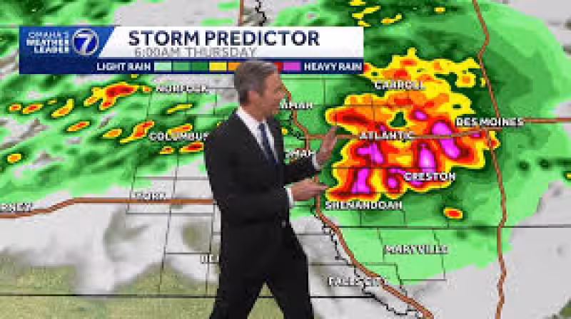
Strong storms were expected to develop very early Thursday morning across the Omaha metro, eastern Nebraska and western Iowa, with the best chance for rain and thunder arriving before sunrise. Any storms that do form could bring big hail, strong winds and heavy rain, and the wettest stretch could hang around through the morning drive before sliding into Iowa.
The timing matters because Wednesday had already turned hot, with temperatures well into the 90s across the metro and humidity expected to fall by evening as west winds gusted over 25 mph. That same pattern was helping set up the overnight threat, while a Tornado Watch remained in effect from about Falls City through Clarinda until 9:00 PM, with the best chances for storms in that area before 5:00 PM.


For Omaha, the window to watch is after 3:00 AM Thursday. Storms developing overnight across eastern Nebraska and western Iowa could be strong enough to dump heavy rain well into the morning commute, then keep more scattered showers around until noon. After that, northwest winds could gust over 30 mph at times Thursday afternoon, and highs in the metro were expected to stay around 80 degrees.
That is a sharp contrast from the first day of the CWS, which was expected to bring highs in the mid to upper 80s, plenty of sun, a little breeze and low humidity. The game-day forecast looks calm enough, but the region's overnight pattern is not completely settled, and severe storms were still possible across parts of the Missouri River Valley on Saturday.
After that front moves through, temperatures were expected to drop into the 70s for a couple of days. Sunday was likely dry, a few isolated thunderstorms might return Monday, and highs around 90 degrees were expected to come back for the second half of next week. For now, the most likely disruption is before sunrise Thursday, when the strongest storms could reach the metro just as the morning begins.


