


Winter Weather Advisory Expanded as Snow Heads Into Maine This Weekend
A Winter Weather Advisory is in effect for large portions of Maine as sunshine and unseasonably mild conditions on Thursday give way to snow arriving late Friday afternoon and evening ET. Officials have also issued a winter storm warning for part of the state while the rest remains under advisory-level impacts.
Winter Weather Advisory and winter storm warning details
The latest notices place parts of Maine under a winter storm warning, with additional areas covered by the Winter Weather Advisory. Thursday will be the calm before the change, with lots of sunshine and temperatures in the mid-to-upper 30s, near 40 degrees, before the precipitation moves in.
A potential weak sea breeze on Thursday afternoon could leave coastal towns a bit cooler than inland communities and may cause some minor snowmelt at the coast prior to the system's arrival. The next round of snow is expected to begin in the late afternoon/evening ET on Friday and continue into the overnight hours, impacting commutes and travel through Saturday morning ET.
What to expect Friday night into the weekend
Snow will develop during the later afternoon and evening ET on Friday, affecting the evening commute. The heaviest precipitation is expected at the onset of the event, with some periods of wet snow at times. The majority of the snow is forecast to move out by daybreak Saturday ET, and later Saturday there should be some improvement with the sun trying to reappear.
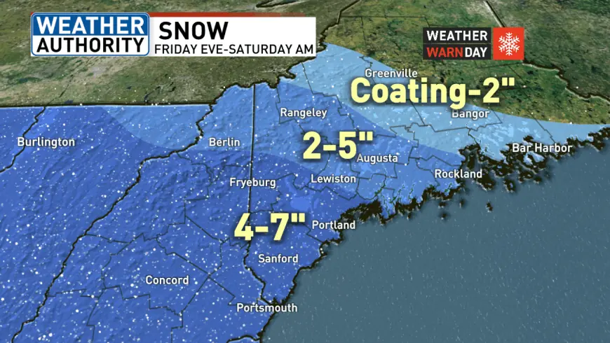
Forecast accumulations vary by region: far western and southern areas are expected to see about 4 to 7 inches; interior and mountain zones around 2 to 5 inches; and a coating to 2 inches spanning from Somerset County to Down East Maine. These totals mean travel could be difficult Friday night, particularly early in the storm when snow may fall heavily.
Travel, timing and weekend outlook
Friday morning ET is expected to have no weather-related travel delays, but the evening commute will be the one to watch as snow begins before typical rush-hour periods. By Saturday afternoon conditions should begin to improve, and Sunday looks to be the best day this weekend with partly sunny skies and temperatures in the middle 30s.
Residents in advisory and warning areas should prepare for reduced visibility and potentially slick roads during the Friday night period. The expectation of wet snow at times could increase the chance of heavier, slushy accumulations near the coast where temperatures hover closer to freezing.
Monitor local statements for any changes, and allow extra time for evening travel Friday ET if you must be on the roads. With the system exiting by daybreak Saturday ET and some sun returning later that day, the most disruptive impacts are likely concentrated in the Friday evening into Saturday morning timeframe.