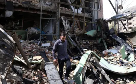


Lake Tahoe Avalanche Near Castle Peak Leaves Eight Dead, One Missing as Rescues Give Way to Recovery
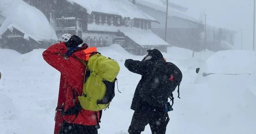
A catastrophic avalanche in the Castle Peak area northwest of Lake Tahoe has left eight backcountry skiers dead, with one person still missing and feared dead, after a slide swept through a group traveling near the Frog Lake Huts during a powerful Sierra storm. Six people survived and were rescued, but officials have indicated the operation shifted from urgent rescue to recovery as conditions and the scale of the debris field became clear.
The avalanche struck Tuesday, February 17, 2026. Authorities received an emergency call around midafternoon Eastern Time. The group involved was part of a guided, multi-day backcountry trip led by Blackbird Mountain Guides in the Tahoe National Forest region near Castle Peak and Frog Lake. The team consisted of 15 people total, including four guides and 11 clients. Officials have said survivors included one guide and five clients.
What happened at Castle Peak and why the Frog Lake Huts area is central
The Castle Peak backcountry is popular because it offers alpine terrain close to major corridors while still feeling remote once you leave the road-accessible zones. The Frog Lake Huts sit in the same broad recreation area and are frequently used as an overnight base for multi-day tours. That convenience can be deceptive: storms can close roads and cut visibility, while wind-loading and rapid snowfall can turn familiar slopes into high-consequence terrain in hours.
In this case, the avalanche hit as the group was moving through the backcountry near the huts and Castle Peak ridgelines. Survivors attempted immediate companion rescue efforts before additional rescuers arrived, and officials have described a difficult scene shaped by severe weather, unstable snow, and the sheer scale of the slide.
Behind the headline: incentives, stakeholders, and why these incidents escalate fast
Avalanche disasters are rarely about a single bad decision. They are usually the result of stacked pressures that narrow options:
-
Weather and timing pressure: Multi-day itineraries can create a powerful urge to finish a route and return to trailheads on schedule, especially when storms threaten roads and visibility.
-
Terrain traps and wind-loaded slopes: Castle Peak’s complex bowls, gullies, and leeward features can amplify avalanche consequences. Even a “short” runout can pile debris deeply.
-
Group dynamics: Guided groups add structure and expertise, but they also carry responsibility for client expectations, route commitments, and the challenge of managing multiple skill levels in harsh conditions.
Stakeholders extend beyond the victims and families. Search teams face elevated risk operating under avalanche hazard and whiteout conditions. Local jurisdictions must coordinate resources, including aviation support when available, while mountain rescue groups balance urgency against responder safety. Guiding operations confront immediate scrutiny over route selection and risk management, even as the larger truth often depends on details that take weeks to confirm.
What we still don’t know about the Lake Tahoe avalanche
Several key facts that will determine the full picture have not been publicly confirmed in detail:
-
The precise slope angle, aspect, and elevation of the starting zone
-
Whether the group encountered natural avalanche activity earlier that day
-
The exact sequence of travel decisions immediately before the slide
-
The size classification of the avalanche and how far it ran
-
Whether there was any usable video or GPS track data that clarifies timing and spacing
-
The condition and location of the remaining missing person within the debris field
Those details matter because they shape both accountability discussions and future safety lessons, including how storms and wind-loading affected Castle Peak terrain on that specific day.
California winter storm impacts and Caltrans road conditions around Tahoe
The same storm that set the stage for dangerous avalanche conditions also produced major travel disruptions. Interstates and mountain passes around the Tahoe region, including Interstate 80 over Donner Summit, experienced closures, chain controls, and intermittent reopenings as snow and spinouts reduced visibility and traction.
For people traveling to or through the Tahoe area, the practical takeaway is that conditions can change multiple times in a single day during active storms. Road status can shift quickly from open with restrictions to fully closed, and closures can strand travelers and complicate emergency response access.
What happens next: realistic scenarios and triggers
-
Recovery resumes when conditions allow, with crews likely using probes, organized search grids, and potentially specialized equipment once avalanche danger drops.
-
Investigators compile a definitive timeline using survivor interviews, device data, and any route documentation from the guided trip.
-
A formal avalanche incident report is developed, focusing on snowpack structure, storm inputs, wind effects, and terrain selection.
-
The guiding industry and backcountry community reevaluate travel choices during peak storm cycles, especially near hut systems that encourage multi-day commitments.
-
Public safety messaging intensifies around Tahoe backcountry corridors that feel accessible but become extremely hazardous under rapid loading.
Why it matters
This is not only a tragedy for the families affected; it is a stark reminder that Tahoe’s proximity to highways and resorts does not reduce backcountry risk. If anything, easy access can increase exposure by drawing more people into avalanche terrain during storms. The Castle Peak and Frog Lake area is a cornerstone of local backcountry recreation, and this incident will likely reshape how many skiers and riders interpret storm-day objectives, guided or not, for the remainder of the season.