


North Carolina weather: Winter storm warning fades, but cold and hazards linger Monday
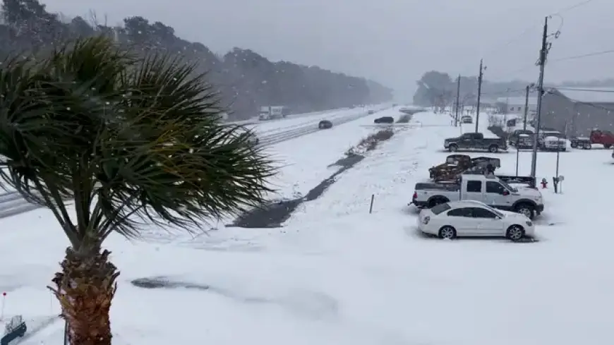
A powerful winter system has left much of the Carolinas and coastal Virginia digging out, and the headline for weather tomorrow (Monday, February 2, ET) is not fresh snow everywhere—but the aftereffects: lingering slick roads, hard-freeze nights, and gusty winds that can keep conditions dangerous even after the worst snowfall ends. Across north carolina, many communities are still dealing with snow-packed side streets and spotty travel as temperatures stay below freezing overnight.
Below is a snapshot of charlotte nc weather, asheville weather, and virginia beach weather for Monday, with the most important context: what’s likely on the ground from the weekend storm.
| Location | Monday, Feb. 2 forecast (ET) | What it means |
|---|---|---|
| Charlotte, NC | Partly sunny, high ~41°F, low ~18°F | Daytime thaw is limited; refreeze risk overnight |
| Asheville, NC | Partly sunny, high ~39°F, low ~15°F | Mountain roads stay slick; cold and wind remain factors |
| Virginia Beach, VA | Mostly cloudy, windy, high ~38°F, low ~27°F | Snow/ice hang on; strong winds and coastal hazards continue |
North Carolina weather outlook for Monday
For much of the state, Monday brings a modest warm-up by afternoon, but it’s still a cold day by local standards. Even where skies turn partly sunny, daytime highs in the upper 30s to low 40s won’t do much for shaded roads, bridges, or neighborhoods where snow was compacted by traffic.
The bigger issue is the night: lows in the teens mean any meltwater can refreeze quickly. That sets up a classic “looks wet, drives icy” problem for the Monday morning and Monday night commute windows, especially on untreated roads and on-ramp/off-ramp areas.
Winter storm warning updates and what remains risky
A winter storm warning that covered large parts of the Carolinas was set to expire Sunday morning for many interior North Carolina counties, but the end of a warning does not end the impact. The storm has been paired with very cold air and strong wind gusts, creating blowing snow, sudden visibility drops, and pockets of near-whiteout conditions during the peak of the event.
Even after the heaviest bands move out, two hazards tend to persist:
-
Hard-packed snow that becomes slicker as temperatures swing around freezing.
-
Gusty winds that can drift snow back onto cleared lanes and knock down tree limbs weakened by ice or earlier loading.
If you’re hearing “blizzard” in conversation, treat it as a description of conditions, not a guarantee for every neighborhood. The more reliable signal is what drivers see: visibility, drifted lanes, and whether the pavement is bare or glazed.
Charlotte NC weather: where travel can surprise you
In the Charlotte area, lingering travel problems are mainly about what’s already on the roads. Recent storm messaging has highlighted additional accumulations that varied widely across the region, with some corridors seeing significantly more snow than nearby neighborhoods.
Monday’s partly sunny forecast helps, but it’s not a quick fix. If roads were plowed down to a thin, compacted layer, the sun often softens it just enough to create slush, then temperatures drop and lock that slush into a rough ice layer overnight. That’s when minor hills, neighborhood turns, and intersections become the trouble spots.
For anyone driving early Monday, expect the worst patches in places that stay shaded—near tree lines, underpasses, and along north-facing stretches.
Asheville weather: mountain wind and cold keep roads slick
In and around Asheville, the mountain environment amplifies the risk. Snow can linger longer at higher elevations, and strong winds can whip across exposed ridges, creating drifting and inconsistent road conditions from one mile to the next.
Monday looks somewhat brighter than Sunday, but the numbers still matter: a high near 39°F with a low near 15°F means freeze-thaw cycles continue, and any untreated surface can stay slick well into the day. If you’re heading out of town, be prepared for quick changes in road texture and visibility, especially where blowing snow has piled into lanes or shoulders.
Weather Virginia Beach: snow, wind, and coastal flooding concerns
For weather virginia beach, Monday’s story is two-part: lingering snow/ice and a wind-and-water setup that can keep conditions rough near the coast.
The weekend storm brought heavy snow and high wind potential in the broader area, with the risk of whiteout conditions and tree damage during the height of the event. Even if snowfall tapers, strong winds can remain an issue for travel—especially for high-profile vehicles.
Along the shoreline, large surf has been a notable hazard, with wavy 10-foot breakers possible in the surf zone at times. Coastal flooding concerns have also been elevated during higher tide cycles, which can push water into low-lying streets and cut off familiar routes near tidal waterways. If you’re moving around Monday morning, plan extra time and avoid roads that routinely flood during storm-driven tides.
Sources consulted: U.S. National Weather Service, Associated Press, The Washington Post, The Guardian


