


Snow Storm Weather Forecast: Arctic Blast Fuels Lake-Effect Whiteouts Now, Bigger South-to-East Ice and Snow Threat Late Week
A fast-changing winter pattern is driving two separate hazards across the Northern Hemisphere: a dangerous cold surge with lake-effect snow already producing near-whiteout travel in parts of the U.S. Midwest, and a larger storm signal that could spread a disruptive mix of snow and ice from the southern Plains into the eastern U.S. later this week. In parts of central Europe, heavy mountain snowfall is also keeping avalanche danger elevated as conditions fluctuate.
Snow storm weather forecast for the U.S.: Lake-effect bands and extreme wind chills (Now–Tuesday)
The most immediate concern sits downwind of the Great Lakes, where narrow, intense lake-effect snow bands can dump heavy snow in a short time and abruptly cut visibility to near zero. Travel impacts have already been severe in parts of western Michigan, where a major multi-vehicle pileup highlighted how quickly conditions can deteriorate when gusty winds combine with fast accumulation.
Alongside the snow, the cold itself is the story. Wind chills in some Great Lakes communities are expected to plunge well below zero, creating a “minutes, not hours” risk window for frostbite on exposed skin and making any breakdown or road closure significantly more dangerous.
What to watch through Tuesday (ET):
-
Rapidly shifting snow bands that can turn a clear drive into a whiteout in a few miles
-
Blowing and drifting snow, especially on open stretches and near lakeshores
-
Wind chills that can remain dangerously low even after snowfall rates ease
-
“Refreeze” hazards on treated roads where temperatures stay too low for salt to work effectively
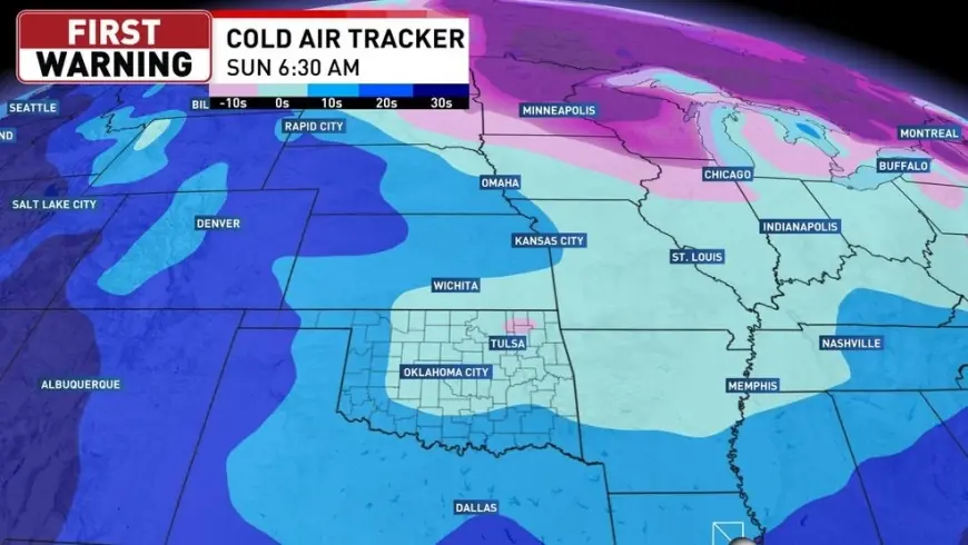
Late-week snow and ice setup: Southern Plains to the Mid-Atlantic (Friday–Weekend)
A broader storm threat is taking shape for late week into the weekend, with signals for a widespread area of wintry precipitation extending from parts of Texas and Oklahoma toward the lower Mississippi Valley, the Tennessee Valley, and into sections of the Carolinas and Mid-Atlantic.
The highest-impact zone may not be where the deepest snow falls, but where temperatures hover near freezing and moisture arrives at the same time. That’s the recipe for sleet and freezing rain, which can glaze roads, weigh down trees and power lines, and trigger large-scale travel disruptions even with modest precipitation totals.
Key impacts to plan around (ET / GMT):
-
Friday into Saturday: greatest risk window for a long corridor of mixed precipitation
-
Ice risk: most concerning where surface temperatures stay at or below 32°F (0°C) while warmer air rides in aloft
-
Heavy wet snow risk: areas just cold enough for snow can see rapid accumulation that clings to branches and lines
-
Uncertainty zone: the rain–ice–snow line can shift 50–150 miles as the storm track changes, so local outcomes may change quickly
Practical steps before the late-week system arrives:
-
Charge power banks, update emergency kits, and ensure you have blankets, water, and a flashlight in the car
-
If you must drive, plan daylight travel and share your route; carry traction aids if you have them
-
Prepare for spotty outages in any area that ends up in prolonged freezing rain
Europe: Mountain snow raises avalanche concerns in the Alps (Next 24–48 hours)
Across parts of the Alpine region, recent snowfall and wind loading are keeping avalanche danger elevated, particularly on steeper terrain where drifting snow forms unstable slabs. Conditions can improve briefly with drier weather, then worsen again if winds increase or new snow arrives. Anyone traveling into higher elevations should treat off-piste routes and steep gullies as especially risky during this cycle.
If you meant a local forecast: Cairo and most of Egypt
If your search is for a snow storm weather forecast near Cairo, current winter precipitation outlooks show no meaningful snowfall expected, with snow accumulation risk essentially near zero. For Egypt, the more common winter disruptions come from rain bursts, localized flooding, and wind-driven dust rather than snow.
What happens next
The near-term Great Lakes lake-effect threat remains a high-variability event: the exact towns hit hardest can change hour to hour as wind direction shifts. The late-week southern-to-eastern storm signal is the bigger “calendar risk” for widespread disruption, especially where ice becomes the dominant precipitation type.
If you tell me your city (or even just the country/region), I’ll turn this into a tight, location-specific snow storm weather forecast with timing, temperature thresholds, and the most likely precipitation type.