


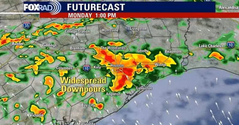
FOX 26 issued a Storm Alert for Monday as Gulf moisture was expected to turn scattered showers into widespread storms and heavy downpours across Southeast Texas. Rain that had already begun Sunday was set to keep building through midweek, with the heaviest bands capable of dropping enough water fast enough to cause street flooding.
The National Weather Service said 1 to 2 inches had already fallen in the area by 7:30 p.m. Sunday, with another 1 to 2 inches still possible. That is enough to keep roads soggy on its own, but the bigger concern is what happens when storms repeatedly track over the same neighborhoods. The forecast called for 2 to 5 inches of rain through midweek, with isolated totals of 6 to 8 inches, and said southeast Texas remained under a 2 out of 4 risk for street flooding Sunday, a threat expected to last through Tuesday.

A Flood Advisory was in effect for parts of Harris and Montgomery County until 9:30 p.m. Sunday, underscoring how quickly conditions were worsening before the Monday alert even arrived. Heavy downpours were expected locally from Sunday through at least Tuesday, and periods of moderate to heavy rain were forecast through Wednesday as a weak tropical low and a front dropping in from the north kept feeding moisture into the region.
The setup was straightforward, even if the outcome was not. Deep moisture over the Gulf was helping fuel the rain, while a weak area of low pressure along the coast of eastern Mexico continued to send disorganized showers and storms toward the area. Forecasters said overall conditions for further development of that system were low, but it could re-emerge in the Gulf Tuesday or Wednesday. That leaves the main question in the short term not whether Southeast Texas will get more rain, but where the heaviest bursts will set up and which neighborhoods will see the quick flooding first.
For residents, the next few days are about watching for rounds of rain, not a single storm. The rain threat is expected to stay active through Wednesday, with the most troublesome period coming when showers stall or keep crossing the same streets. John Dawson delivered the latest outlook for Southeast Texas, and the message for Monday was clear: keep the umbrella close, and keep an eye on water pooling where it can rise fastest.


