


A new tornado warning was issued for Jackson County until 9:15 p.m. Saturday as severe weather alerts spread across the Kansas City metro during a First Warn Weather Day.
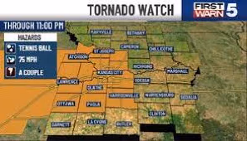
Tornado warnings were also posted for Clay, Jackson, Platte and Wyandotte counties, while a destructive severe thunderstorm warning covered Jackson, Cass, Johnson and Miami counties until 9 p.m. Residents were warned to be ready for damaging winds up to 80 mph. A tornado watch remained in effect through 11:00 pm tonight, and a severe thunderstorm watch also covered Nodaway, Holt and Andrew counties through the same time.
The biggest threat for the metro was expected between 8 pm and 11 pm, the same window when conditions were most likely to turn dangerous before things calmed overnight. A flood watch also was in place for the metro and areas to the south through tomorrow morning, adding another layer of risk for people under the warnings.

Forecast models suggested the storms may not hit every spot the same way. Instead of one solid line, the system could organize into a broken line or clusters moving toward the metro through the evening, which means some neighborhoods may see the worst of it while others are spared. The severe and tornado threat was still present to the north in Nodaway, Holt and Andrew counties, but it was expected to be a little lower there.
Saturday was marked as a First Warn Weather Day, the highest alert for impactful weather, because the setup included damaging winds, hail, possibly a couple of tornadoes and flood potential. A cold front was expected to push through and improve conditions by Sunday, when the weather should turn dry, partly cloudy and less humid with a high of 73.
After that, the next uptick comes Tuesday, when there is a low 30% chance for isolated showers and non-severe storms. Wednesday brings the next better chance for storms, at 50%, with gusts up to 40 mph possible. For now, the most immediate deadline is still the clock on Jackson County’s tornado warning and the broader watch that runs through late evening.


