


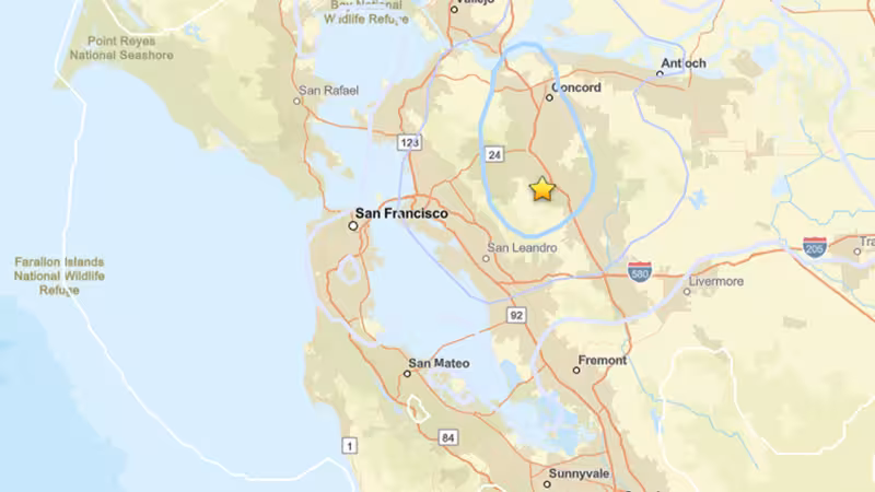
A preliminary magnitude 3.6 earthquake shook the San Francisco Bay Area at 8:37 a.m. Pacific time on Sunday, centered about 1 mile southwest of Alamo, Calif., at a depth of 9 miles, the USGS said.
The initial report listed the event as magnitude 3.6. No injuries or major damage were reported, and subsequent quakes were recorded in the same area, which officials treated as likely aftershocks.
The USGS listed the location and depth in its early bulletin and posted a preliminary shake-severity map soon after the event. Residents near Alamo and across parts of the East Bay experienced the morning tremor; emergency services reported no calls for serious damage.
Seismologists cautioned that the 3.6 figure is preliminary. Teams at the USGS will review additional seismic data and cross-check records from regional networks before issuing any final magnitude, and that process can change both the numeric magnitude and the visual shading on shake maps.
Aftershocks were reported in the hours following the first quake. Such follow-up events are commonly minor adjustments along the same portion of a fault that slipped in the initial rupture; aftershocks can occur days, weeks or even years after the first earthquake.
Because the initial reading is based on rapid automated analysis, the most important immediate variable is how many and how large the subsequent quakes prove to be. The available reports list multiple smaller events clustered near the initial epicenter, but the exact count and characterization of those quakes remain under review.
The practical consequence for residents is limited: a shallow, low-to-moderate magnitude event like this rarely produces widespread damage, and no reports of major harm were filed. The scientific consequence is different — analysts will use the incoming waveform data to refine the magnitude, depth and the shake-severity distribution shown on USGS maps.
The one clear uncertainty that matters now is the final magnitude and the aftershock sequence. If the USGS revises the number upward or downward after detailed analysis, the change will shift the official record and could alter how the event is categorized in studies of Bay Area seismicity.
USGS scientists said they will update their public products after completing the review of additional recordings. That review is the next step readers should watch: it will decide whether the 3.6 label stands and how the series of subsequent quakes will be logged on the agency’s maps and charts.


