


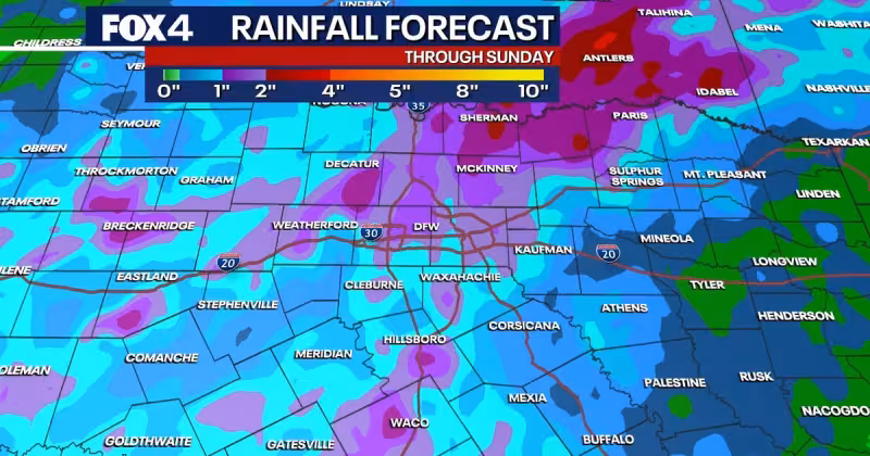
North Texas is heading into a wet weekend, with multiple rounds of showers and storms expected from Friday through Sunday and flash flooding the main threat. Residents around the Metroplex should be ready for changing conditions fast, especially on Saturday, when rain chances are highest.
Isolated and scattered thunderstorms are expected across parts of North Texas on Friday, although afternoon showers will likely miss the Metroplex before more widespread scattered storms arrive Friday night. The National Weather Service says the storms could bring gusty, erratic winds, frequent lightning and heavy downpours, and an area of low pressure to the southwest will keep feeding the system through Sunday.
Saturday is the day most likely to get soaked. Multiple rounds of rain are expected, with temporary lulls between bands of storms, and locally heavy rainfall is possible from morning through evening. That raises the risk of flash flooding across the region, especially where repeated downpours pass over the same areas. Scattered, heavy rain should then continue into Sunday, keeping the weekend unsettled even after any brief breaks.

The forecast leaves one question unresolved for now: how much rain will fall in the hardest-hit parts of North Texas. What is clear is that outdoor plans across the region could be interrupted at short notice, and boaters on area lakes should use extra caution as storms move through.
Conditions should improve next week as high pressure builds over the region and cuts off rain chances. Highs are expected to settle into the 90s starting Monday, with heat index values approaching triple digits at times. After a wet and stormy weekend, North Texas is set to turn hot quickly.
Officials also advise waiting at least 30 minutes after the last sound of thunder before resuming outdoor activities.


