


Tropical Cyclone Horacio: Earth’s first Category 5 tropical cyclone of 2026 and why South Indian Ocean conditions mattered
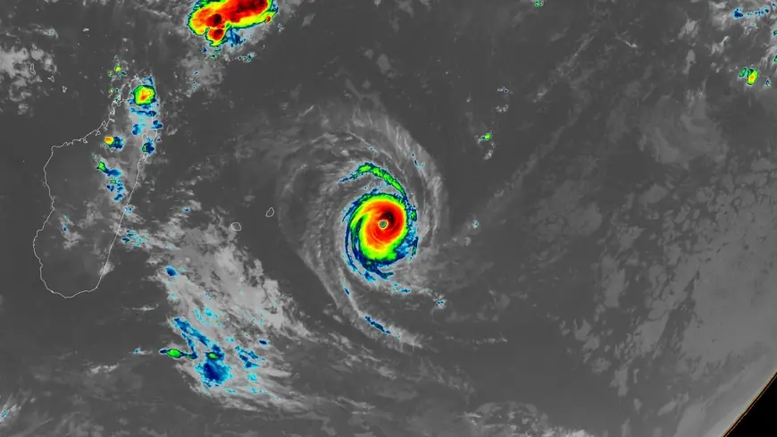
Why this matters now: tropical cyclone horacio became a striking early indicator of how favorable ocean conditions can push storms to extreme intensity. It reached Category 5 strength on Monday afternoon, February 23, with peak winds of 160 mph (260 km/h) over remote South Indian Ocean waters. The same warm sea surface temperatures and moderate wind shear that powered Horacio are the proximate reasons it reached that threshold—and they connect to longer-term shifts in cyclone behavior.
Tropical Cyclone Horacio: ocean factors and the broader pattern
Sea surface temperatures in the area were 27–28°C (81–82°F) and wind shear was moderate—conditions that allowed rapid intensification. The event fits a larger signal noted in recent material that climate change is expected to increase the proportion of tropical cyclones reaching Category 4 and 5 strength. Here’s the part that matters: the local environment was primed for peak intensity, which helps explain how tropical cyclone horacio topped out so quickly.
Peak intensity and the immediate forecast
The storm topped out at 160 mph (260 km/h) winds on Monday afternoon, February 23, while centered over warm, remote South Indian Ocean waters. Forecast guidance from monitoring agencies indicates Horacio has likely peaked and is expected to steadily weaken as it moves southward into cooler waters and a region of higher wind shear. Horacio remains far from any land areas and is listed as a threat primarily to marine interests.
How Horacio compares with recent Category 5 events
Horacio is the first Category 5 tropical cyclone of 2026 and the first Category 5 in the Southern Hemisphere since Cyclone Errol reached that intensity off the coast of northwestern Australia on April 16, 2025. The 1990–2025 average yearly number of Category 5 storms globally was 5. 3. In 2025 there were five Category 5 storms globally: Hurricanes Melissa, Erin, and Humberto in the Atlantic; Typhoon Ragasa in the Northwest Pacific; and Cyclone Errol in the South Indian.
It’s easy to overlook, but the appearance of a Category 5 this early in 2026 underscores the variability and clustering of extreme storms in recent seasons.
Quick timeline and forward signals
- April 16, 2025 — Cyclone Errol reached Category 5 off northwestern Australia.
- 2025 season — five Category 5 storms recorded globally: Melissa, Erin, Humberto, Ragasa, Errol.
- February 23, 2026 (Monday afternoon) — Horacio reached Category 5 strength with 160 mph (260 km/h) winds.
Forward signals to watch that would confirm the next phase: sustained movement into cooler water and higher shear would align with forecasts calling for steady weakening; persistence of warm surface waters and lower-than-expected shear could prolong high intensity, although current guidance favors weakening.
Additional context and publication notes
Republish note: the original material states that articles may be republished for free online or in print under a Creative Commons Attribution-NonCommercial-NoDerivatives 4. 0 International License. Most content other than images is available to republish under CC BY-NC-ND 4. 0. A separate item in the provided context contained the line "Click here if you are not redirected automatically. " The item with the author line was credited to Jeff Masters, Ph. D., with a byline date of February 23, 2026. Jeff Masters, Ph. D., worked as a hurricane scientist with the NOAA Hurricane Hunters from 1986–1990. After a near-fatal flight into Category 5 Hurricane Hugo, he left the Hurricane Hunters to pursue — unclear in the provided context.
The real question now is how often these early-season peaks will appear in coming years, and whether larger-scale ocean patterns will create more opportunities for storms to reach Category 4 and 5 strength.
What’s easy to miss is how much the local sea surface temperature and wind shear environment determines short-term intensity swings; global trends shape the backdrop, but the immediate conditions are the catalyst for a storm becoming extreme.