


Winter Storm Watch Raises Stakes for NYC Commuters and Jersey Shore — 12+ Inches Possible
A Winter Storm Watch is now centered on the New York City and New Jersey region, and the immediate impact will fall first on commuters and coastal communities if the system trends toward a higher‑end outcome. Forecasts in play show a range from moderate accumulations to pockets exceeding 12 inches, with the clearest effects likely during the late Sunday into early Monday travel period.
Who faces the most disruption under this Winter Storm Watch
Here’s the part that matters: travel and the morning commute could be the earliest and most visible casualties. Forecast model guidance suggests heavier snowfall across southern and central New Jersey — including shore communities — while the New York City area is within range for higher totals in some model scenarios. Planners and commuters should treat the Winter Storm Watch as a prompt to review plans for late‑weekend travel and early‑week work arrangements.
What’s easy to miss is the sensitivity of outcomes to the storm’s exact track: a modest east–west shift of roughly a few dozen miles would change which population centers see the deepest snow. Forecasters note that if the system moves just offshore and intensifies, snowfall totals will rise sharply; if key ingredients fail to come together, accumulations will be much lighter.
Storm mechanics and the forecast picture
Forecasters are tracking a developing coastal nor'easter expected to move offshore and strengthen. Several elements must align for a high‑impact snowstorm: a precise coastal track, a robust burst of cold air, and consolidation of the system as it moves along the mid‑Atlantic and Northeast corridor. Model spreads are currently producing divergent scenarios — from a moderate event (several inches) to localized totals above a foot in the most amplified runs.
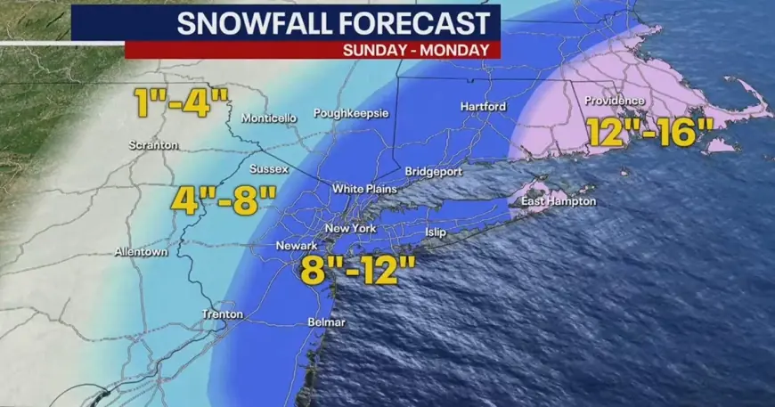
- Range of modeled snowfall highlighted in recent forecasts: roughly 5–12 inches for parts of the NYC area, with pockets of 12+ inches possible.
- Forecast emphasis: highest totals trending toward southern and central New Jersey, with more variability northward.
- Timing signal: precipitation risk increases late Sunday and could continue into early Monday, affecting the Monday morning commute.
Snow would be limited if the storm jogs away from the coast or if cold air is insufficient. Forecasters expect the outlook to sharpen in the days immediately before the event as newer model runs come in.
Micro timeline for planning (subject to updates):
- Saturday: forecast remains relatively dry and milder.
- Late Sunday: colder, windier conditions increase; precipitation risk rises.
- Late Sunday into early Monday: accumulating snow possible, with travel impacts likely by Monday morning.
Local officials and transportation managers will be watching model trends closely; the real question now is how tightly the storm hugs the coast during its peak phase. If the track trends a bit west, coastal and nearby inland areas could see the highest snowfall. If it jogs east, impacts will be significantly reduced for large populations.
Practical implications: residents and employers in the NYC‑NJ corridor should finalize contingency plans for the Monday commute, keep flexible schedules in mind, and monitor updates over the next 24–48 hours as forecast confidence improves. The forecast window remains dynamic, and newer data this weekend will narrow the spread of possible outcomes.
(Writer’s aside) The bigger signal here is the growing model agreement on a coastalizing system; the degree of coastal intensification will be the pivotal factor for whether the event becomes a significant snow producer for dense metro and shore areas.