


Dc Weather: Snow risk rising for DC region ahead of Sunday storm
Forecasters are watching a weekend system that is expected to bring rain Sunday morning before changing to a wintry mix and wet snow by Sunday night, a shift that could deliver anything from a localized 1–3 inches to much heavier totals depending on the storm’s track. This dc weather threat follows a milder stretch that produced partial sunshine and middle 50s on Saturday.
Models split on a rain-to-snow transition Sunday
Through Saturday, temperatures are forecast to remain above freezing, with the warmest day of the week likely Saturday afternoon when readings climb into the middle 50s. By Saturday night, though, forecasters expect a sharp dip in the jetstream and temperatures falling back into the 30s overnight Saturday into Sunday, setting the stage for a changeover in precipitation Sunday night.
Dc Weather track and timing
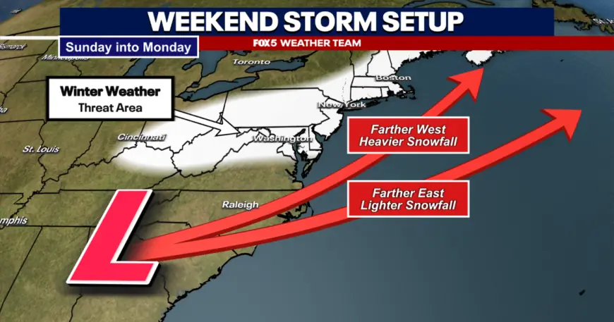
Most guidance now shows the system arriving as rain on Sunday morning before a surface storm pulls east and colder air moves in along an inverted surface trough, producing a transition to sleet and then wet snow Sunday night. The inverted trough pattern tends to produce a relatively narrow band of accumulating snowfall that follows the trough axis, so the heaviest snow would be localized rather than uniform across the region.
How much snow could fall — two model scenarios
One solution, which has been favored by the European model, would keep the initial precipitation as mainly rain through the front part of Sunday before colder air allows a changeover late Sunday night; that setup could produce about 1–3 inches in parts of the region, with an upside risk of 3–6 inches in the band. By contrast, the American model has suggested a stronger storm that stays closer to the coastline with a faster influx of cold air, producing a widespread heavy snowfall with final totals in the double digits for much of the area.
Forecasting exactly where the band of accumulating snow would set up remains difficult. The narrowness of the inverted trough-driven band means a small shift in the storm track would change who sees significant accumulation, and forecasters say they likely will not have a clearer picture until Saturday evening.
Mike Thomas has been tracking the differing solutions and notes the key variables are the storm’s track and intensity; if the stronger, coastal solution materializes Sunday, the region could see much more impactful snowfall than the European-model outcome.
The immediate consequence for the region is uncertainty for travel and operations late Sunday into early Monday; the storm is expected to exit late Sunday night into early Monday morning, ending the precipitation as the system pulls away and colder air fills in.
Forecasters will be issuing updates as models refine the track on Saturday evening and into Sunday; the next confirmed milestone is the expected rain on Sunday morning followed by the potential changeover to snow Sunday night, with final snowfall coverage and totals hinging on how close the low track stays to the coast.