


weather los angeles: Evacuation warnings for burn-scar areas ahead of powerful winter storm
Los Angeles authorities have issued evacuation warnings for communities in recent wildfire burn-scar areas as a strong winter storm moves into the region. A flood watch is in effect from Monday morning through Monday evening ET, and officials are warning of fast-moving debris flows, flash flooding and hazardous travel conditions.
What residents should expect and when
The approaching system is forecast to deliver heavy rain and thunderstorms across a wide swath of the county. Weather officials have highlighted the potential for intense rainfall rates, powerful gusts and isolated tornadic activity. Meteorological briefings indicate localized downpours could reach roughly one inch per hour in some cells, and wind gusts approach 60 mph in exposed areas.
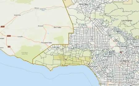
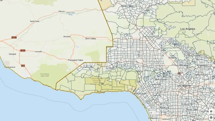
Authorities emphasize heightened risk for hillsides and areas denuded by recent fires: rock and mud slides can occur near steep terrain, and debris flows can move rapidly through channels and canyons that were previously scorched. Evacuation warnings for select parcels near burn scars are active through 9: 00 a. m. ET Tuesday, and residents in those zones are urged to be ready to leave if an evacuation order is issued.
How local response teams are preparing
City and county teams have mobilized personnel and resources to reduce hazards and speed emergency response. Public works crews are on standby to address blocked roadways and fallen trees, while fire and sheriff units will monitor vulnerable neighborhoods. Outreach efforts are targeting unhoused individuals in high-risk corridors, with shelter options being coordinated where needed.
The mayor has urged people in susceptible areas to plan ahead, avoid driving on flooded roads, and make evacuation plans now. Officials are staging equipment and personnel ahead of the heaviest rainfall window so they can respond quickly to incidents such as flooding, downed power lines and stranded motorists.
Safety steps for residents and motorists
Residents in warning areas should assemble an emergency kit, finalize evacuation routes and have a communication plan with family or neighbors. Move vehicles to higher ground if you are in a flood-prone area and secure loose outdoor items that could be blown around by strong gusts.
On the roads, drivers are advised to reduce speed, increase following distance and avoid driving through standing water. Never attempt to cross moving water, even if it appears shallow; roadbeds can be washed out and vehicles can be swept away. If you encounter heavy lightning or hail, seek shelter and avoid open areas and tall objects.
Staying informed
Officials will issue updates and may broaden evacuation areas or move from warnings to mandatory orders if conditions deteriorate. Residents should keep batteries charged, monitor emergency communications from local authorities, and follow guidance from first responders. Interactive maps and alert systems maintained by local emergency management provide the most current evacuation zones and shelter locations.
This event is expected to be another significant rain episode for the region. Those in burn-scar zones and other vulnerable neighborhoods should use caution on the roads, plan for possible power or service interruptions, and be prepared to evacuate with minimal notice.