


blizzard warning in effect for North Shore as heavy snow and 55 mph gusts expected tonight
Forecasters are warning of a rapid shift to wintry conditions this evening, with a mix of rain, sleet, freezing rain and heavy snow moving into the region after 6: 00 PM ET. Strong east winds and coastal enhancements will produce blizzard conditions along the North Shore, making travel hazardous or impossible overnight.
What to expect tonight and Wednesday
Beginning this afternoon and intensifying after 6: 00 PM ET, precipitation will transition from scattered wintry-mix showers to steadier, heavier precipitation across the area. The southernmost counties are expected to see mainly rain or a rain-sleet mix through the night, but colder air northward will support significant snow. Temperatures will hover in the upper 20s to lower 30s.
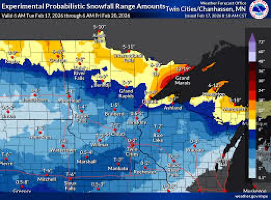
Winds out of the east will gust up to 55 mph tonight, increasing blowing and drifting of fresh snow. By 6: 00 AM ET Wednesday, most locations along the Ports and the North Shore are forecast to have received 4–8 inches of new snow. Snow will continue Wednesday, with sustained east winds of 15–30 mph and gusts near 50 mph at times. By Wednesday sunset, totals are expected to range from 6–12 inches in the Ports and 10–16 inches along the North Shore, with locally higher drifts along exposed shorelines and ridgelines. Elsewhere, accumulations will be lighter, generally a trace to 6 inches.
Travel, power and safety concerns
Blizzard conditions are likely to develop along the North Shore tonight. Visibility may drop to near zero in heavy snow and blowing snow, and roads could quickly become impassable. A layer of ice is also possible on treated and untreated surfaces where freezing rain mixes in early, creating additional hazards for vehicles and pedestrians.
Travel should be avoided if possible from tonight through much of Wednesday in the hardest-hit areas. Motorists who must travel should prepare for slick, snow-packed roads, long delays, and the potential for stranded vehicles. Strong winds increase the risk of downed tree limbs and isolated power outages, particularly where wet snow loads combine with gusty conditions.
Households should secure outdoor items, charge devices, and have an emergency kit ready, including warm clothing, blankets, food, water and any necessary medications. Those with critical medical needs should make contingency plans in case of interrupted services or blocked roads.
Outlook for Thursday and Friday
On Thursday morning, lingering snow showers are expected near the head of the lake and across parts of the region, but snow will taper in the Ports by late morning. Highs will climb into the lower 30s with northwest winds easing to 5–15 mph, though spotty flurries could linger in colder pockets.
Attention will turn to a second system late Friday. Confidence in its track remains limited, with model guidance showing disagreement on the exact path. If the system verifies over the area, an additional 1–6 inches of snow is possible, with colder temperatures in the 20s and northerly winds. Forecasts are subject to change; residents in the region should monitor updates and be prepared for rapidly changing conditions.
Emergency and travel officials advise avoiding nonessential trips during the peak of the storm and preparing for widespread impacts from heavy snow, ice, and powerful winds.