


severe thunderstorm warning issued as Central Valley storm brings funnel cloud risk, lightning and mountain snow
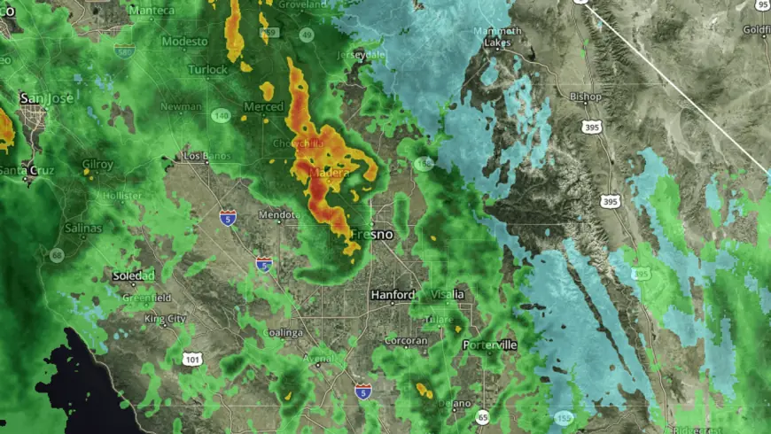
A fast-moving storm system moving through California's Central Valley prompted a severe thunderstorm warning for parts of Fresno, Merced and Madera counties on Monday, February 16, 2026 (ET). The advisory highlighted the potential for funnel clouds, frequent lightning and rapidly changing hazardous conditions for residents in the affected area.
Where and when the threat is concentrated
The Significant Weather Advisory covered portions of central San Joaquin Valley counties, with the most acute thunderstorm threat focused on low-lying valley communities and adjacent foothills. Meteorologists noted that conditions could shift quickly as the storm progressed east to west, producing strong wind gusts, intense lightning, and localized heavy rainfall. Mountain areas received a separate kind of impact: snow was reported at higher elevations, including visible snowfall at Shaver Lake and China Peak on Monday, February 16, 2026 (ET).
Thunderstorm activity was already producing frequent lightning within the advisory zone. Officials warned that funnel clouds could develop in the convective storms, elevating the risk for brief but dangerous tornado-like vortices, particularly in the southern and eastern fringe of the advisory area.
Expected impacts and safety guidance
Residents in the warned counties were urged to be prepared for rapid deterioration in weather. The primary hazards from the storms included:
- Funnel clouds and possible brief tornadoes capable of producing localized damage;
- Frequent cloud-to-ground lightning, posing risk to people and outdoor equipment;
- Strong, gusty winds that can down trees and power lines and make travel hazardous;
- Localized heavy rainfall that may lead to ponding on roadways and reduced visibility;
- Snow in higher elevations, which could affect mountain roads and recreation areas.
Safety recommendations emphasized seeking sturdy shelter immediately if a funnel cloud or tornado is observed or a warning is issued for your location. When lightning is present, stay indoors and avoid exposed outdoor structures. Drivers were advised to reduce speed, use headlights, and pull over if conditions make driving unsafe. Those in the mountains were reminded to use caution on snow-covered roads and to check road conditions before traveling.
Local impacts and preparedness steps
Although the storm system was relatively short-lived, its fast pace raised concerns about rapid-onset hazards. Emergency responders and community officials urged residents to monitor updates from local authorities and to have a basic emergency kit ready that includes a flashlight, batteries, medications, and provisions for at least 72 hours. Power outages from lightning strikes and wind damage were possible; charging mobile devices and securing loose outdoor items were recommended as immediate preparedness steps.
For those in mountain communities, the snowfall visible at Shaver Lake and China Peak on Monday, February 16, 2026 (ET) served as a reminder that winter conditions can accompany late-winter storm systems in the region. Travel plans involving mountain passes should account for potential delays and the need for chains or traction devices.
Officials stressed that conditions can change rapidly during convective weather episodes and urged vigilance throughout the day and evening. Residents were encouraged to use weather-alert tools available to them and to heed any instructions from local emergency management when severe thunderstorm warnings or tornado warnings are issued for their immediate area.
As the storm system moves through the Central Valley, communities remain on alert for additional rounds of thunderstorms and winter precipitation in the higher terrain. Those in affected counties are advised to stay informed and to prioritize safety until the risk subsides.