


Flash Flood Warning for Los Angeles as Thunderstorms Hit Burn-Scar Areas and Mountain Snow Builds Across California
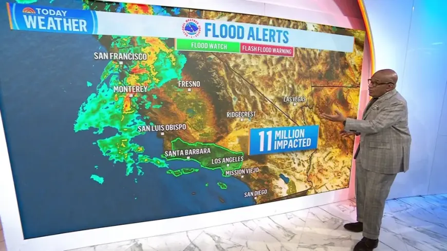
A flash flood warning is in effect for parts of Los Angeles County Monday, February 16, 2026, as heavy rain and thunderstorms move through the region and elevate the risk of fast-moving flooding, road washouts, and debris flows—especially near recent burn scars. The warning is set to run through 7:00 p.m. ET, with emergency officials urging residents to avoid flooded roads and to be ready for sudden changes in conditions.
The storm is arriving with an unusually volatile mix for Southern California: bursts of intense rainfall, gusty winds, and the kind of short-duration downpours that can overwhelm drainage systems even when totals don’t look extreme on paper.
Los Angeles weather today: where the flash flood warning is focused
The warning covers sections of Los Angeles County where thunderstorms have already produced roughly 2 inches of rain or more in spots, with flooding either ongoing or expected to begin quickly. The most dangerous impacts are often the most localized: an underpass that fills in minutes, a canyon road that becomes impassable, or a hillside that sheds mud and rock after the ground saturates.
A critical factor Monday is the heightened vulnerability around burn-scar terrain. When vegetation is stripped away and soil structure is altered by fire, runoff accelerates. That raises the odds of mudslides and debris flows even in neighborhoods that rarely see flood problems in calmer storms.
Practical impact is immediate: standing water can stall commutes, emergency closures can appear with little notice, and even brief thunderstorm bursts can force rapid responses from police, fire, and public works crews.
What a flash flood warning means and why it’s different from a watch
A flash flood warning is issued when flash flooding is imminent or already happening. In other words, it’s not a “keep an eye on it” message—it’s a “take action now” message. The hazard is speed: flash floods can develop in minutes, and drivers often underestimate how quickly moving water can sweep a vehicle.
The safest rule remains simple: do not drive through flooded roadways. Many flood fatalities occur in vehicles because depth is hard to judge and pavement can be washed out underneath.
Snowfall weather forecast: why this storm is also a big mountain story
While Los Angeles is dealing with rain and flash-flood risk, the same storm pattern is piling snow into California’s higher elevations. Mountain snowfall forecasts point to significant accumulations in the Sierra Nevada and other high terrain, creating dangerous travel conditions, reduced visibility, and high-impact road restrictions.
This matters for Southern California even if the snow is not falling downtown: the state’s major travel corridors and mountain passes can become choke points. It also complicates emergency response, because resources may be stretched across flood response in lower elevations and winter-weather impacts up high.
For anyone heading toward mountain communities, the risk isn’t just snow totals. It’s the combination of wind, blowing snow, whiteout conditions, and chain controls that can quickly turn a routine drive into a hazardous situation.
Behind the headline: incentives, stakeholders, and what makes this system so disruptive
The storm’s biggest headline driver is its impact timing: intense rain arriving during active weekday hours amplifies disruption, and thunderstorms make conditions harder to forecast street by street. That uncertainty changes behavior. Residents want clear guidance, but officials have to communicate in probabilities—especially when the worst impacts may hit only a handful of neighborhoods.
Key stakeholders and pressures include:
-
Residents in flood-prone zones and near burn scars, who face the highest physical risk
-
Drivers and commuters, who are most likely to encounter sudden road flooding
-
Emergency managers, who must balance rapid alerts with avoiding warning fatigue
-
Utilities and public works, dealing with clogged drains, fallen debris, and localized outages
-
Mountain communities, managing snow impacts as lowland areas manage flooding
The second-order effects can last beyond the rain window: mudslide cleanup, damaged roads, disrupted school and work schedules, and insurance claims that rise when water enters garages, basements, and lower floors.
What we still don’t know
Several pieces will determine whether this becomes a short, sharp event or a prolonged disruption:
-
Exactly where the heaviest thunderstorm cores set up through the evening
-
How quickly rainfall rates drop after the most intense bands pass
-
Whether any debris-flow hotspots activate in the most vulnerable slopes
-
How much additional moisture arrives later in the week, potentially re-wetting saturated ground
What happens next: 5 realistic scenarios and triggers
-
Localized flash flooding expands if thunderstorms repeatedly track over the same corridor. Trigger: persistent lightning and heavy radar echoes in one zone.
-
Rapid debris flows occur near steep terrain and burn scars. Trigger: intense rainfall bursts after the ground is already saturated.
-
Commute impacts linger even after rain eases. Trigger: stalled vehicles, road closures, and cleanup operations.
-
Mountain travel turns hazardous overnight as snow and wind increase. Trigger: chain controls, low visibility, and crashes.
-
A quieter Tuesday follows with scattered showers and spotty slick roads. Trigger: residual moisture and lingering low clouds.
Los Angeles’ forecast over the next several days stays on the cool, unsettled side, with periodic showers possible midweek and again later in the week. The big message for Monday remains urgency: flash flooding can be fast, uneven, and deadly—especially when heavy rain meets vulnerable terrain.