


Fire Weather Watch: Eastern Plains Face Red Flag Threat Sunday; Gusts, Low Humidity Raise Risk
Forecasters are warning of heightened wildfire danger across eastern Colorado this weekend after several areas saw unusually warm temperatures and breezy conditions. A Red Flag Warning will be in effect Sunday from 1 p. m. to 7 p. m. ET for portions of the eastern plains, where gusts and very low humidity could allow any ignition to spread rapidly.
What to expect Sunday
Expect an afternoon shift toward critical fire weather across the warned area. Relative humidity values are forecast to fall into the low teens, with some spots dropping near 11 percent. Southwest winds are expected to strengthen through the afternoon, producing gusts up to 40 mph in and near the metro-adjacent plains during the 1 p. m. –7 p. m. ET window.
Those conditions — dry air, gusty winds and receptive fine fuels such as cured grasses — create a prime environment for rapid fire growth. Forecasters note the threat is not limited to just one day; elevated fire risk is likely to persist into early next week and could expand in coverage and intensity by midweek.
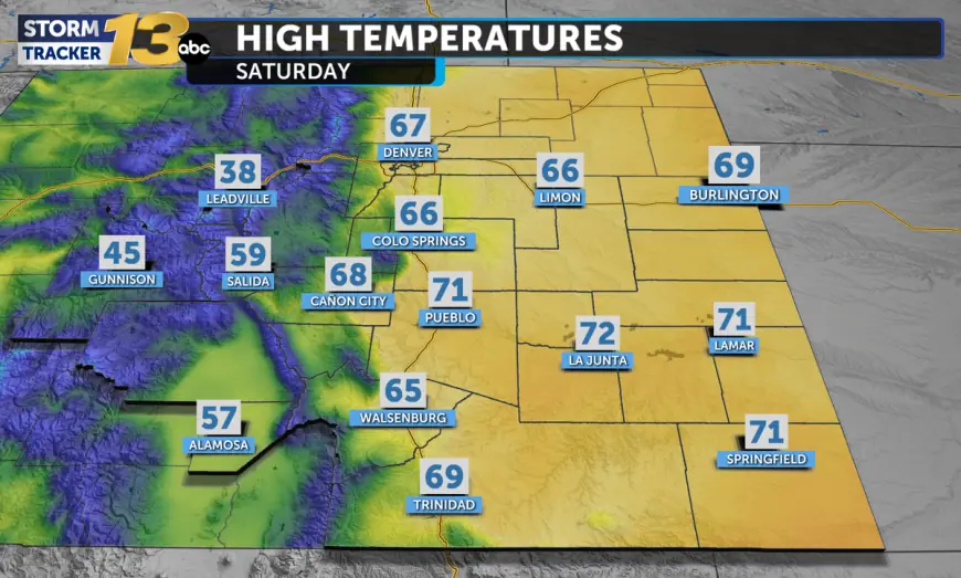
Recent warmth and gusty conditions set the stage
Parts of southern and southeastern Colorado have already seen near-record warmth in recent days, with multiple communities reaching the 70s Saturday. Stronger daytime mixing has produced gusty winds across several counties, with 20–30 mph gusts reported in southern and central zones. While temperatures are expected to dip slightly Sunday, readings will remain above seasonal averages and strong morning-to-afternoon winds will continue to dry out surface fuels.
Those warmer-than-normal conditions combined with persistent gusts are a common precursor to days when officials first place areas under a fire weather watch and then escalate to a Red Flag Warning if parameters tighten. Residents should treat the elevated forecast as a call to reduce risk-taking outdoors until conditions subside.
Safety steps and local impacts
Officials are urging residents to postpone any outdoor burning and to avoid activities that can create sparks, such as operating gasoline-powered equipment, chainsaws, or other machinery that may produce heat or friction. Secure loose patio furniture, trash cans and other items that can become airborne in high winds. Agricultural operators are advised to delay pile burning and be mindful of equipment exhaust and hot surfaces.
Travelers on major routes through the plains may encounter periods of blowing dust and lowered visibility during the afternoon hours. Motorists should be prepared for sudden gusts that can affect high-profile vehicles and trailers, and drivers should reduce speed if visibility diminishes. Rapidly changing conditions mean people in affected counties should monitor local briefings and be ready to act if an incident develops nearby.
While the most acute threat centers on Sunday afternoon and early evening, the prolonged nature of the pattern means communities should remain alert into the start of next week, when some models suggest extreme fire weather could develop in broader swaths of the plains.
The combination of dry air, strong winds and above-average temperatures has produced a fast-moving situation. Residents are encouraged to take practical steps now to reduce the chance an accidental spark becomes a damaging blaze.