


UK braces for snow and flooding with numerous warnings in place
Large areas of Britain remain on alert as a yellow weather warning for snow and ice covers much of Scotland and parts of England, while hundreds of flood warnings and alerts continue to affect communities in England. Authorities have warned of travel disruption, slippery surfaces and ongoing flood risk as conditions evolve into the weekend.
Warnings and affected areas
A yellow warning for snow and ice is in force until Sunday morning ET for swathes of the north, stretching from Derby northwards and covering the majority of Scotland. Models indicate heavy snowfall at times, with likely accumulations of 1–3 cm at lower elevations, 3–7 cm above 150 m and possibly 10–15 cm on higher ground above 400 m. Ice is expected to be an additional hazard, particularly across north‑east England and parts of Scotland, where precipitation falling on frozen ground could create very slippery conditions.
Separately, the south‑west has its own short but sharp warning for icy conditions. A band of rain and sleet moving southwards into Devon and Cornwall is expected to clear overnight; the warning window runs from 12: 00 ET on Friday until 5: 00 ET on Saturday. As skies clear and temperatures drop below freezing, untreated roads, pavements and cycle paths are at risk of icy patches, increasing the chance of slips and falls.
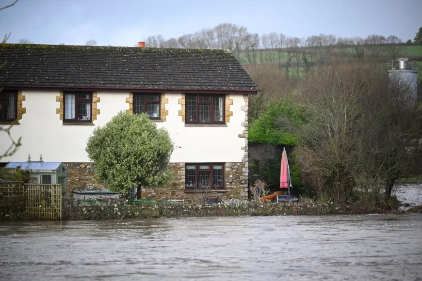
Flooding: scale, impacts and official action
Flood risk remains high across large parts of England. At the latest update there are 74 flood warnings and 163 flood alerts in place. Flood duty teams confirm more than 24, 000 homes and businesses have been successfully protected by temporary defenses and emergency measures, but roughly 330 properties have been inundated so far.
Emergency managers are urging residents in affected river valleys and low‑lying coastal areas to remain vigilant. Where property-level protection has been deployed, people should keep floods doors and temporary barriers in place until authorities indicate risk has passed. Those in locations with active warnings are being advised to avoid unnecessary travel, move vehicles from low‑lying streets and prepare sandbags or other flood defenses if safe to do so.
What to expect over the coming days
The wintry band is expected to turn to rain into Sunday morning ET, with a brief spell of freezing rain possible in some locations before milder air pushes in and a gradual thaw begins. Sunday will start blustery for many, with showery rain and some hill snow. The southwest may see a noticeable milder push, with temperatures potentially reaching around 12°C in parts of Cornwall and Devon, while eastern areas stay cooler at roughly 4–5°C.
Forecasters expect the start of next week to remain unsettled and blustery with further showers across the country, with conditions easing into Tuesday. Another weather system is forecast to arrive on Wednesday, bringing further unsettled weather, before a drier spell looks likely by Thursday.
Practical steps residents can take now include checking local warnings regularly, planning journeys with extra time and winter equipment, and keeping phone batteries charged in case of power interruptions. Those living in flood‑prone locations should review household emergency plans and follow any evacuation advice from local authorities.
With both snow and flood threats unfolding simultaneously, the combination of icy surfaces and standing water could accentuate disruption to transport and community services. Staying alert to updates and heeding official guidance will be essential as conditions change through the weekend and into next week.