


Tornado watch remains in place as Texas braces for severe storms
State officials have activated emergency resources and issued warnings as a potent storm system moves across Texas, bringing a tornado watch, damaging winds, large hail, heavy rain and flash flooding risk into the weekend. Residents in the eastern two-thirds of the state are being urged to stay weather-aware, have an emergency plan and prepare for rapidly changing conditions.
State activates emergency response; residents urged to prepare
Governor Greg Abbott has directed the Texas Division of Emergency Management to activate state emergency response resources ahead of the arriving storms. The governor said the State of Texas is prepared to respond to severe storms anticipated this weekend and urged Texans to monitor road conditions before traveling, remain weather-aware, and have a plan in place in case of an emergency.
Officials say state assets are on standby to support local response efforts. Emergency management personnel are also watching an elevated wildfire risk across parts of South, West and Northwest Texas that could persist into next week, creating a complex public-safety picture amid the severe-weather threat.
Watches and warnings, dangerous conditions expected Saturday evening
Forecasters warn that the storm system will bring the potential for strong to severe thunderstorms, heavy rain, flash flooding, large hail, damaging winds and possible tornadoes. The heightened threat begins later Friday from the Big Bend region to the Red River Valley and is expected to expand eastward through the weekend, encompassing much of the eastern two-thirds of Texas.
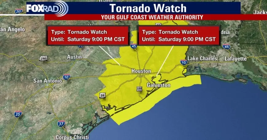
A tornado watch was issued for multiple counties in the Houston-area and other parts of eastern Texas, with the watch in place into the evening hours. In the Greater Houston area the tornado watch was canceled for many counties around 8: 00 p. m. ET, while Chambers and Galveston counties remained under the watch until 9: 00 p. m. ET. Prior warnings had been issued for pockets of southeast Texas earlier in the evening.
At about 6: 50 p. m. ET a tornado warning was issued for parts of Brazoria, Harris and Galveston counties, covering a portion of the coastal plain and nearby inland communities. That warning extended roughly until 7: 15 p. m. ET and cited severe thunderstorms capable of producing tornadoes and extensive straight-line wind damage, moving east at approximately 40 mph. Meteorologists highlighted areas near Pearland and Rosharon as particular concerns during the warning period.
Wind gusts up to 60 mph have been observed in some locations, with the potential to cause damage to roofs, siding and trees. Strong to severe storms are expected to sweep southeast across the region through the evening, with the main window for the strongest storms appearing to begin around 5: 00 p. m. ET northwest of Houston and push into the Gulf by about 10: 00 p. m. ET.
Safety steps for Texans during the watch
Officials urge residents to take basic preparedness steps now: assemble an emergency supply kit, identify a safe shelter area in your home (an interior room on the lowest floor, away from windows), and review a family communication plan. Motorists should be cautious, avoid flooded roadways, and delay travel if conditions are hazardous.
Local emergency managers will issue warnings and updates for specific communities; people should monitor local forecasts and heed guidance from local authorities. With multiple hazards possible—tornadoes, damaging winds, hail and flash flooding—residents should be ready to move to shelter on short notice and keep devices charged to receive alerts through the evening and into the weekend.