


Bomb cyclone threat grows as nor’easter targets the East Coast and Arctic air presses into the Gulf Coast
A potential bomb cyclone is drawing attention heading into the final weekend of January, with a rapidly intensifying coastal storm expected to bring a classic nor’easter mix of heavy snow, strong winds, and dangerous surf along parts of the Eastern Seaboard. At the same time, Florida weather and the Gulf Coast of the United States are dealing with a colder-than-normal pattern that can turn routine rain and wind into higher-impact conditions when temperatures plunge.
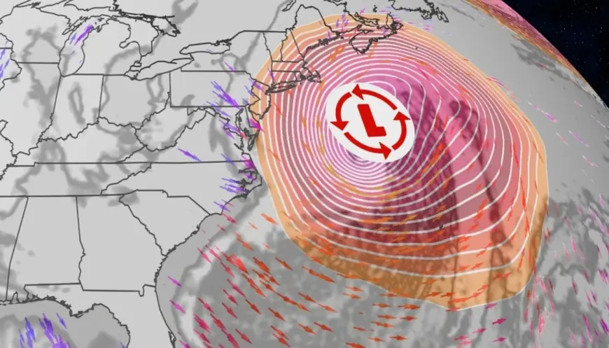
A fast-deepening coastal storm could deliver snow, wind, and coastal flooding
Forecasts point to a low-pressure system developing near the Southeast coast and strengthening quickly as it tracks north, a setup that can pile up heavy precipitation on the cold side of the storm while driving powerful onshore winds along the coast. The greatest snow risk is expected to run from parts of the Carolinas into coastal and inland sections of the Mid-Atlantic, then farther north into portions of the Northeast as the storm evolves late Saturday, Jan. 31, 2026, into Sunday, Feb. 1, 2026, Eastern Time.
The wind component can be as disruptive as the snow. Strong gusts can reduce visibility, create near-blizzard conditions in heavier bands, and increase the risk of tree damage and power outages, especially where the ground is already saturated or where snow loads cling to branches. Coastal flooding and beach erosion are also a concern when a deepening storm pushes water toward shore for multiple tide cycles.
Further specifics were not immediately available.
What “bomb cyclone” and “nor’easter” actually mean
A “bomb cyclone” is not a different type of storm so much as a description of how fast a storm intensifies. Meteorologists use the term “bombogenesis” for rapid strengthening, typically defined by a sharp drop in the storm’s central pressure over roughly a day. Lower pressure generally means a stronger storm, and that rapid deepening often correlates with worsening wind, heavier precipitation, and rougher seas.
A “nor’easter” refers to a coastal storm where the strongest winds typically blow from the northeast over land, driven by the storm’s circulation offshore. These systems thrive when cold air is in place inland while relatively warmer ocean water helps fuel moisture and energy along the coastal front. When the temperature line sets up just right, the same storm can produce heavy snow inland, a messy mix near the changeover zone, and cold rain closer to the coast.
Some specifics have not been publicly clarified, including exactly where the sharpest snow gradient will set up and how far inland the strongest wind gusts will reach.
Florida weather and the Gulf Coast: cold air changes the risk profile
Even if the heaviest snow focuses farther north and east, the Gulf Coast and Florida sit under the broader influence of the same Arctic air mass feeding into the storm track. For much of the central Gulf Coast, the more immediate issue is the combination of bitter cold and wind, which can drive wind chills into dangerous territory and stress heating systems.
In Florida, the impacts are less about snow and more about the chill, rain timing, and marine conditions. Gusty winds can make it feel dramatically colder than the thermometer suggests, and rough surf can make beach and boating conditions hazardous. Inland, the colder air can create pockets of near-freezing temperatures that matter for early-morning travel, outdoor work, and sensitive vegetation.
Two groups tend to feel these patterns first: coastal residents and boaters facing rough seas and high surf, and households without reliable heating or insulation that can struggle during multi-night cold snaps. Utility crews and transportation agencies also get pulled into the spotlight, because wind-driven outages and slick bridges can show up even when snowfall totals vary.
Snow next weekend: what’s plausible and what’s still uncertain
With today being Thursday, Jan. 29, 2026 ET, the most immediate snow concern is the storm expected this weekend, Jan. 31 through Feb. 1. Looking ahead to next weekend, Feb. 7–8, longer-range outlooks support the idea that colder-than-normal air may reload across parts of the eastern United States, which can keep the door open for additional winter weather episodes. The exact storm track and snow placement that far out, however, can shift substantially from day to day.
The practical takeaway is that the pattern is supportive of more winter risk, but it is too early to lock down neighborhood-level snow forecasts for Feb. 7–8 with high confidence. If a new system forms while cold air remains entrenched, snow could reappear along parts of the same corridor. If the track shifts offshore or temperatures moderate, the next event could be mostly wind and rain, or it could stay confined farther north.
The next verifiable milestone will be the issuance of official winter storm and coastal hazard alerts as the weekend system comes into range, followed by updated forecast packages early next week that will better define whether a separate storm threat is emerging for Feb. 7–8.