


Ontario Snowfall Aftershock: Toronto Digs Out From a Historic Snowstorm as “Orange Winter Storm” Alerts Fade Into Polar Vortex Cold
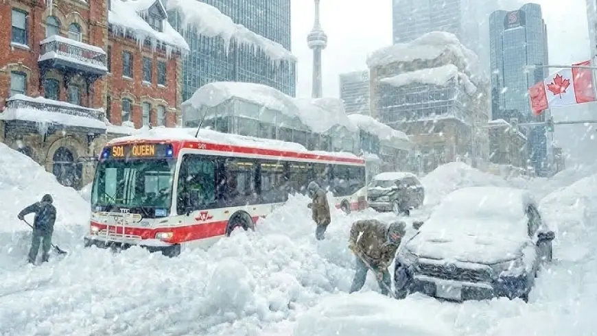
Southern Ontario is moving from storm emergency to recovery grind after a weekend snow event buried parts of the Greater Toronto Area and jammed travel across the region. As of Thursday, January 29, 2026 ET, the snow is largely done in Toronto, but the impacts are not: deep snowbanks, narrowed roads, inconsistent sidewalk clearing, transit bottlenecks, and lingering airport delays are now colliding with a new hazard—bitter polar-vortex cold that turns melt into ice and cleanup into a slower, riskier job.
This is the moment when winter storms cause the most frustration. The blizzard headlines fade, but families are still asking: How much snow did Toronto get? Are schools closed tomorrow? Are school buses running in Simcoe County? Is Pearson still canceling flights? And why does it feel colder than anywhere on Earth?
How much snow did Toronto get
Totals varied sharply across neighborhoods and nearby communities, but the core numbers tell the story: downtown Toronto measured roughly 61 cm of snow from the main burst, while Toronto Pearson Airport logged about 46 cm—a record-setting single-day snowfall for that site. Many GTA locations reported 50 cm or more, with localized bands producing near-whiteout snowfall rates that overwhelmed plows faster than they could keep up.
Those totals matter because the real constraint isn’t just clearing roads—it’s the volume of snow that has to be physically moved and stored. When snow piles reach curb height, visibility drops at intersections, lanes disappear, and even “cleared” routes become slow and hazardous.
Yellow watch vs orange warning: what people are actually seeing
A lot of Ontarians have been tracking “yellow watch” and “orange warning” labels circulating online. In practice, those color tags are shorthand used by some weather feeds to simplify risk. The official alert language is closer to “watch” and “warning,” with “warning” implying higher confidence and more severe or imminent conditions.
The important takeaway isn’t the color—it’s the impacts those alerts are trying to communicate:
-
Heavy accumulation in a short window
-
Blowing snow and sudden visibility drops
-
Dangerous travel and stranded vehicles
-
Knock-on effects like school bus cancellations and flight disruptions
School closures Ontario: why buses get canceled even when schools “open”
Families often assume school closures are about snow depth. In reality, bus safety and pedestrian access drive most decisions—especially for younger students. A district can have clear main roads and still cancel transportation because:
-
Side streets remain impassable
-
Bus stops are buried or icy
-
Sidewalks are not reliably cleared for walking students
-
Extreme cold makes “waiting outside” a genuine hazard
That’s why you’ll often see Simcoe County school buses canceled while schools remain open—a compromise that acknowledges rural routes and drifting snow without forcing a full academic shutdown. It also shifts a burden onto parents: if you can drive safely, class is available; if you can’t, you’re stuck.
What to watch for on Friday, January 30, 2026 ET: cancellations triggered less by new snow and more by wind chill and road-edge narrowing after plows leave high banks.
Toronto Pearson airport cancellations and TTC service alerts: the recovery bottleneck
Airports don’t “reopen” the way a school does; they recover. Even after runways are cleared, cancellations can persist because aircraft and crews are out of position, gates are backed up, and de-icing queues slow the entire schedule. Pearson saw hundreds of cancellations at the peak of the storm, and disruptions can echo for days as airlines rebalance networks.
Inside the city, the TTC’s biggest challenge has been above-ground infrastructure. Snow and drifting can force shutdowns on exposed sections where switches, tracks, and power components are vulnerable. The pattern many riders experienced—partial closures, shuttle buses, and unpredictable headways—is typical after a high-volume snowfall, especially when temperatures then plunge and harden snow into ice.
Polar vortex Toronto: why the cold feels like the “coldest place on earth”
Toronto’s forecast for Thursday and Friday features very low temperatures—with overnight lows deep below freezing and wind chills that can quickly become dangerous. Cold like this changes everything:
-
Salting becomes less effective
-
Snow compacts into ice ruts
-
Vehicle batteries fail
-
Frostbite risk rises fast during waits for buses or tow trucks
When people ask “coldest place on earth today,” they’re usually mixing two ideas: the coldest inhabited places and the coldest measured places. In late January, Antarctica remains the planet’s cold pole overall, while the coldest inhabited readings often show up in northern Canada and Siberia, where temperatures can drop toward the minus 40s and below.
Behind the headline: what’s really driving the chaos
Context is the hidden story. Toronto and the surrounding region can handle ordinary snow, but a storm of this magnitude exposes pressure points: limited snow storage space, uneven sidewalk responsibility, and a transportation network that depends on precise timing.
The incentives are misaligned:
-
Cities prioritize arterial roads; residents feel the pain on side streets and sidewalks
-
School systems prioritize safety; families prioritize predictability and childcare
-
Airlines prioritize network recovery; travelers prioritize a single flight that departs on time
Second-order effects are already visible: delivery delays, missed work shifts, rising minor-injury visits from slips and falls, and a widening gap between neighborhoods that clear quickly and those that don’t.
What happens next: 5 realistic scenarios with triggers
-
Faster stabilization into the weekend
Trigger: sustained cold and sun reduce new precipitation and crews catch up on hauling. -
More bus cancellations without full school closures
Trigger: wind chills and icy stop conditions make transportation unsafe even if buildings open. -
A spike in collisions and pedestrian injuries
Trigger: refreeze cycles turn packed snow into slick ice, especially at intersections and bus stops. -
Continued Pearson disruption even after roads improve
Trigger: aircraft positioning and de-icing lines remain the limiting factor, not runway clearance. -
A renewed debate over sidewalk clearing and winter equity
Trigger: residents compare neighborhoods and ask why safety depends on who lives on your block.
Ontario’s storm story is no longer about snowfall totals alone. It’s about how a dense region manages recovery when snow volume, transit reliability, school logistics, and polar-vortex cold all hit the same week—and when “back to normal” becomes a moving target.