


Winter Storm Fern: Snow Totals, Ice, Power Outages, and Flight Cancellations After the January 2026 Winter Storm Weekend
A sprawling January 2026 winter storm widely nicknamed Winter Storm Fern has just finished its cross-country run after a disruptive weekend stretch from Saturday, January 24 through Monday, January 26 (ET). The storm’s legacy on Tuesday, January 27 (ET) is less about fresh snowfall and more about lingering ice, dangerous refreeze, extended power restoration, and a travel system still trying to reset.
Even in places where the snow has stopped, the combination of ice load + gusty winds + bitter cold behind the system is keeping conditions hazardous and slowing recovery.
What happened: a long-duration snow and ice storm swept from the South to New England
Fern combined deep cold air with multiple waves of moisture, producing a corridor of heavy snow, pockets of sleet, and a broad zone of freezing rain. The most damaging impacts were concentrated where ice accretion built for hours, loading trees and power lines and turning roads into skating rinks.
As the storm shifted east, it evolved into a classic high-impact setup for the Mid-Atlantic and Northeast: plowable snow for many, but still mixed precipitation and sharp cutoffs where a small temperature change flipped snow to sleet or glaze.
How many inches of snow are we getting: what the numbers look like by region
If you’re asking “how much snow are we getting this weekend,” the key point is timing: the core Fern event was this past weekend (January 24–26 ET). Most locations are now in a cleanup phase, with only localized additional snow possible in colder wraparound or lake-effect zones.
Here’s a practical snapshot of what fell in some of the hardest-hit corridors (amounts vary sharply over short distances):
-
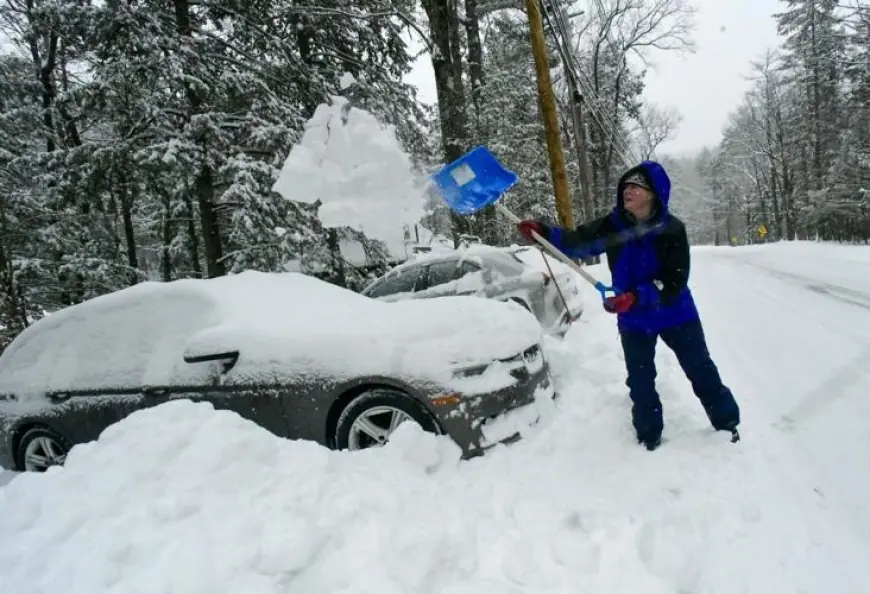
Ohio Valley into northern Kentucky and southern Indiana: a broad swath of about 6 to 13 inches of snow and sleet in the heaviest banding, enough to create major road impacts and prolonged cleanup.
-
Mid-Atlantic: major metro areas saw significant accumulations; Washington, DC reported around 7 inches, with higher totals nearby in favored corridors.
-
Great Lakes (select metro areas): weekend totals commonly landed in the mid to upper single digits in heavier bands.
-
Southwest (higher terrain focus): some mountainous locations saw extreme totals measured in feet, underscoring how expansive the storm’s snow footprint became.
Where snow totals were lower, ice often did the real damage—especially in parts of the Southeast where snowfall was minimal but freezing rain persisted.
Winter storm warning zones and why ice became the main story
Snow is disruptive. Ice is destructive.
In portions of the Southeast, winter storm warnings and ice storm warnings were driven by forecasts for ice accumulation ranging roughly from a quarter inch up to around an inch in the most vulnerable pockets. That’s the range where:
-
Tree limbs begin snapping under load,
-
Power lines start galloping or failing,
-
Roads become dangerous or impossible even with treatment,
-
Restoration takes longer because crews must clear debris before repairs.
Some communities in the Carolinas and nearby higher elevations emphasized that snow amounts were expected to be modest, while ice remained the primary concern, including scenarios approaching about a half inch in the most exposed areas.
Power outages near me: why restoration can take days, not hours
Nationally, outage counts surged as the ice zone expanded, with peak totals reaching well into the seven figures at the worst point. On Tuesday (January 27 ET), the headline is the restoration grind:
-
Downed trees and blocked access delay line repair.
-
Cold temperatures slow melting and keep roads slick, limiting bucket-truck positioning.
-
Prioritization often runs: hospitals and water systems first, then dense neighborhoods, then rural taps.
A key detail: even after power returns, refreezing can keep roads hazardous, and spotty re-outages can occur when partially weakened limbs finally fall.
Flight cancellations, delays, and travel recovery: what to expect now
Air travel took a major hit during the storm’s peak, with Sunday, January 25 (ET) standing out as one of the worst single days for weather-related cancellations in years. Monday also saw thousands more cancellations and widespread delays, and Tuesday (January 27 ET) is expected to improve—but not evenly.
What travelers should watch now:
-
Crew and aircraft repositioning: even after skies clear, planes and crews may be in the wrong cities.
-
Deicing backlogs: cold air can keep deicing demand high even after precipitation ends.
-
Hub ripple effects: disruptions in one major airport cascade nationwide.
Behind the headline: why Fern hit so hard, and why it’s not “just weather”
Context: The storm arrived in a pattern that favored repeated cold intrusions, then exploited a moisture feed that kept precipitation going long enough to build serious totals.
Incentives:
-
Utilities must balance speed with safety—repairing energized lines in icy debris fields is hazardous.
-
Transportation agencies face a brutal tradeoff: pretreat early and risk wash-off, or wait and risk instant glaze.
-
Airlines cancel proactively because a controlled cancellation is cheaper than stranded planes, timed-out crews, and passengers stuck overnight.
Stakeholders: households without heat, hospitals and long-term care sites, trucking and delivery networks, airports, school districts, and insurers all absorb different pieces of the same event.
Second-order effects: price spikes for ice melt and generator fuel, supply delays, school closures that impact hourly workers, and higher crash risk in the “it looks fine” phase after plows pass but black ice forms.
What we still don’t know
-
The final peak outage number and how many customers experience multi-day restoration
-
Full infrastructure damage totals (trees, lines, transformers)
-
How quickly a meaningful warm-up reaches the hardest-hit ice zones
-
Whether another organized system develops for the coming weekend, or if the pattern relaxes
What happens next: 5 realistic scenarios to watch this week and this weekend
-
Refreeze nights (most likely): clearing skies plus cold air create black ice each evening. Trigger: temperatures dropping below freezing after daytime melt.
-
Faster restoration: warmer afternoons and improved road access accelerate repairs. Trigger: sustained above-freezing highs and lighter winds.
-
Long-tail outages: rural and heavily wooded areas lag. Trigger: widespread tree damage and repeated minor re-outages.
-
Another storm threat by the weekend (uncertain): an active pattern could reload. Trigger: a new low tracking near the coast with cold air in place.
-
Travel normalization with pockets of disruption: most routes recover, but a few airports remain snarled. Trigger: deicing demand and backlog clearance speed.
For anyone still asking “how many inches are we getting,” the most accurate answer now depends on where you are—because Fern’s main snow and ice has largely fallen, and the next risk in many areas is ice, not inches.


