


UK Snowstorm to Blanket Major Cities with 69 Inches
Advanced weather models indicate that a significant winter snowstorm is set to impact the UK on February 9. This storm could deliver up to 69 inches of snow, primarily across the Scottish hills. Nearly 90% of the country is expected to experience snowfall on this date.
Storm Details
The European Centre for Medium-Range Weather Forecasts (ECMWF) has predicted a powerful blizzard that will begin in South Wales and southern England. Key regions in the storm’s path include:
- Peak District
- Yorkshire Dales
- Pennines
- Various areas in Scotland
Expected Timeline
Snowfall is projected to start early on February 9. By 6 AM, heavy snow will begin battering regions across:
- England
- Wales
- Northern Ireland
Cities like London, Birmingham, Nottingham, Manchester, Liverpool, Cardiff, and Belfast should prepare for significant snowfall.
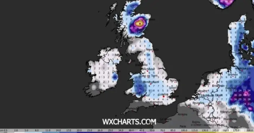
Snow Accumulation Forecasts
Accumulation estimates reveal the storm’s potential severity:
- Scottish hills: up to 175 cm (69 inches)
- South Wales: around 20 cm (8 inches)
- Northern England: approximately 8 cm (3 inches)
- Northern Ireland: up to 4 cm (1.5 inches)
By midday on February 9, most of Britain will likely be covered in snow. The Met Office has also issued alerts about potential “wintry hazards” during this period.
Long-Term Weather Outlook
The Met Office’s forecast for February indicates that the wettest weather may concentrate in central and southern areas. Conversely, the north and northwest could experience drier conditions. The presence of colder air in the northeast raises the possibility of additional wintry hazards.
Early snowfall could occur prior to February 9, particularly from January 30 to February 8. The Met Office warns of potentially heavy rain, especially in the southern and western regions, with chances for wintry showers as cold air interacts with incoming fronts.
As the storm approaches, residents are encouraged to stay updated and take precautions for possible severe weather conditions.


