


New Jersey Winter Storm: NJ Snow Totals Climb to 17 Inches as NJ Transit Restarts on a Severe Weather Schedule
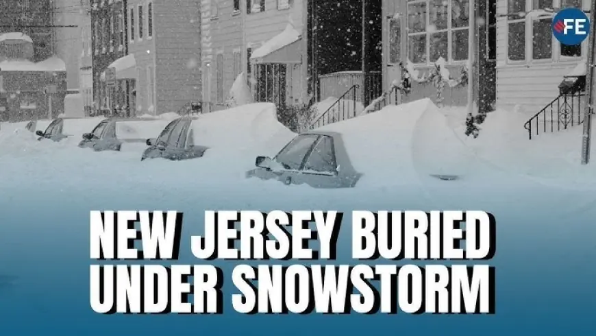
New Jersey is digging out from a big winter storm that delivered widespread snow, a sharp burst of ice in some areas, and a long tail of dangerous cold. As commuters check weather snowfall totals and refresh NJ Transit updates, the two biggest questions remain the same: how many inches of snow fell in each town, and is NJ Transit running today as the work week restarts under winter conditions.
The storm’s “mix line” — where snow changed to sleet or freezing rain — shifted just enough to create big differences in totals from one county to the next. Meteorologist Dan Zarrow summed up what many forecasters wrestled with: small track changes can flip a forecast from “all snow” to a snow-and-ice event fast, especially in New Jersey’s tight coastal-to-inland gradient.
Snow totals NJ: how many inches of snow fell in New Jersey?
Final snowfall totals from the winter storm showed the highest accumulations stacked in the northwest, with many communities reaching the mid-teens. The top-end NJ snow totals hit 17 inches in parts of Sussex County, while much of northern and western New Jersey landed in the 12–16 inch range.
Selected snowfall totals NJ (storm total):
-
Branchville (Sussex County): 17.0"
-
Stockholm (Sussex County): 17.0"
-
Newton (Sussex County): 16.0"
-
Green Pond (Morris County): 16.4"
-
Tenafly (Bergen County): 16.3"
-
Newark area: around 10–11" (airport-region measurement)
In general, the snow totals NJ pattern looked like this:
-
Northwest (Sussex/Morris and nearby): 14–17" (highest totals)
-
North and parts of the northeast corridor: 10–15"
-
Central Jersey: often 6–12" depending on sleet/freezing rain timing
-
South Jersey: lower snow totals in many spots where mixing/icing cut into accumulation
That spread is why “snow totals nj” and “how many inches of snow” became the dominant searches: the total changed dramatically over short distances.
NJ state of emergency snow: what it meant on the ground
Ahead of the storm, the governor declared a New Jersey state of emergency for all 21 counties, a move that supports coordinated response and reinforces travel warnings. The NJ state of emergency (and “state of emergency NJ” messaging) was paired with restrictions aimed at keeping major roadways clearer for plows and emergency vehicles during the height of the snow storm NJ impacts.
Even after the snow ended, the state of emergency posture mattered because the cleanup phase is colliding with extreme cold — the kind that turns slush into concrete and makes untreated patches refreeze quickly.
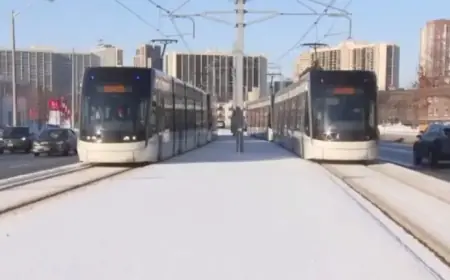
Is NJ Transit running today? NJ Transit schedule and what riders should expect
So, is NJ Transit running today? Yes — but not fully “normal.”
NJ TRANSIT (NJTransit / njtransit) rail service has resumed on a Severe Weather Level 2 schedule, and riders should expect delays and cancellations as crews work through equipment positioning, crew availability, and station-area conditions.
Key points for NJ Transit updates:
-
Most rail lines are operating under the severe weather schedule with knock-on delays.
-
Some services have remained suspended at times (including certain branch services), depending on conditions and staffing.
-
Light rail and bus operations have been restarting in phases, with some bus routes resuming while others remain temporarily suspended until stops are cleared and road access is safe.
For anyone planning a commute, the practical advice is to treat today’s NJ transit schedule as a “flex day” even if you’re back on note-perfect time: leave earlier than usual, and expect last-minute platform or departure changes.
Current weather: weather now turns bitterly cold after the storm
The current weather across much of New Jersey has shifted into the storm’s most dangerous after-effect: arctic cold.
Weather now (representative conditions):
-
North Jersey (Newark area): cloudy, low 20s°F
-
Central Jersey (Trenton area): cloudy, mid 20s°F
-
Coastal South (Atlantic City area): clearer at times, mid 20s°F, breezy
The NJ weather headline is wind chill and refreeze. Side streets, ramps, and sidewalk edges can glaze over overnight, and even daytime sun won’t do much when highs stay in the teens and 20s.
When will the snow start again? Next NJ snow storm signal is low-confidence
After this winter storm snowfall totals event, many residents are already asking: when will the snow start again?
The short answer: no immediate snow is locked in for midweek, but there are early signals of another potential system late Saturday into Sunday. Right now, confidence is limited — the range of outcomes still includes “minor snow,” “mix,” or “miss.” In other words, it’s something to watch, not something to plan around yet.
What’s next for New Jersey
With totals tallied and transit slowly normalizing, the state’s next challenge is the cold: clearing storm drains, widening plowed lanes, and preventing ice buildup around stations and bus stops. The storm may be over, but the impacts — from NJ transit updates to slick walkways — will linger until temperatures climb back above freezing.