


Philadelphia Snowfall Prediction: Storm’s Path Determines Weekend Totals
The Philadelphia region is bracing for a significant winter storm expected this weekend. With current temperatures feeling like they are in the single digits and teens, the coldest air of the season will be felt as highs remain in the teens and low 20s over the weekend.
Cold Conditions and Snowfall Prediction
This incoming storm could deliver varying snowfall totals, heavily influenced by its path. Meteorologists are currently focusing on several key factors that will determine how much snow falls in Philadelphia.
Snow-to-Water Ratio
- The air will be exceptionally cold, resulting in a high snow-to-water ratio.
- A 20:1 ratio implies that one inch of water could yield up to 20 inches of snow, producing light and fluffy snow.
- For instance, a half-inch of water could translate to about 10 inches of snow.
Storm Track Uncertainties
The primary uncertainty is the storm’s track. Current long-range weather models show it moving through the Carolinas and northeast into the Atlantic. This positioning will greatly affect snowfall amounts in Philadelphia:
- If the city is at the storm’s northern edge, snowfall could be as low as a light coating to 3 inches.
- Closer to the storm center could lead to significant accumulations, possibly between 6 to 12 inches or more.
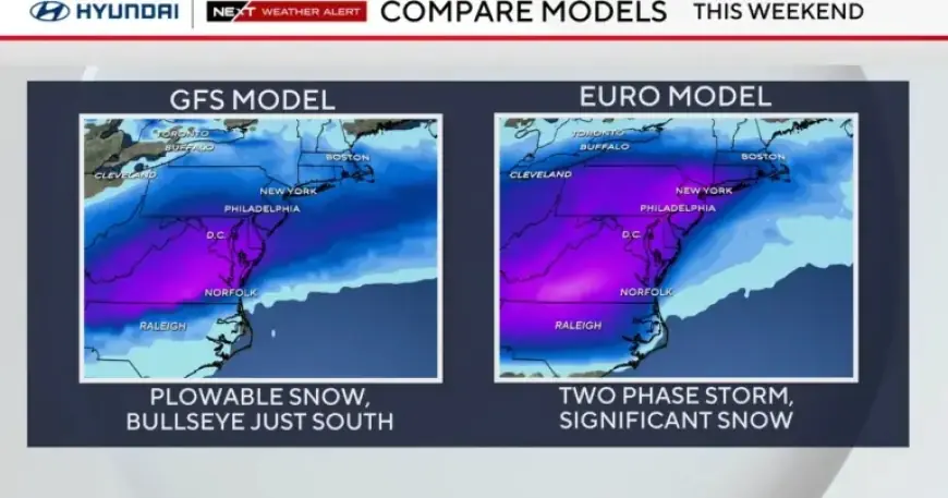
Weather Models Overview
Various weather models present differing predictions:
- European Model (ECMWF): Predicts the heaviest snow from Virginia to Philadelphia and New York.
- American Model (GFS): Suggests the heaviest snow band stretches from Tennessee through Delaware.
- National Blend of Models (NBM): Forecasts significant snowfall from Virginia through northern Delaware.
Timeline for the Winter Storm
The winter storm is expected to develop over the southern plains late this week. It may bring snow and ice starting late Saturday and continuing through Monday evening. Residents should prepare for potentially heavy snowfall.
Preparation and Anticipation
As the storm approaches, it is advisable to stay tuned to local weather updates for any changes in predictions. Be ready with shovels and ice melt, as this storm could produce the heaviest snowfall of the season. Additionally, there may be school delays or closures on Monday, January 26, depending on the storm’s timing and track.
For continuous updates, visit Filmogaz.com for the latest information on the upcoming winter weather.