


N.J. Forecast: Second Weekend Storm to Bring 2-5 Inches of Snow Today
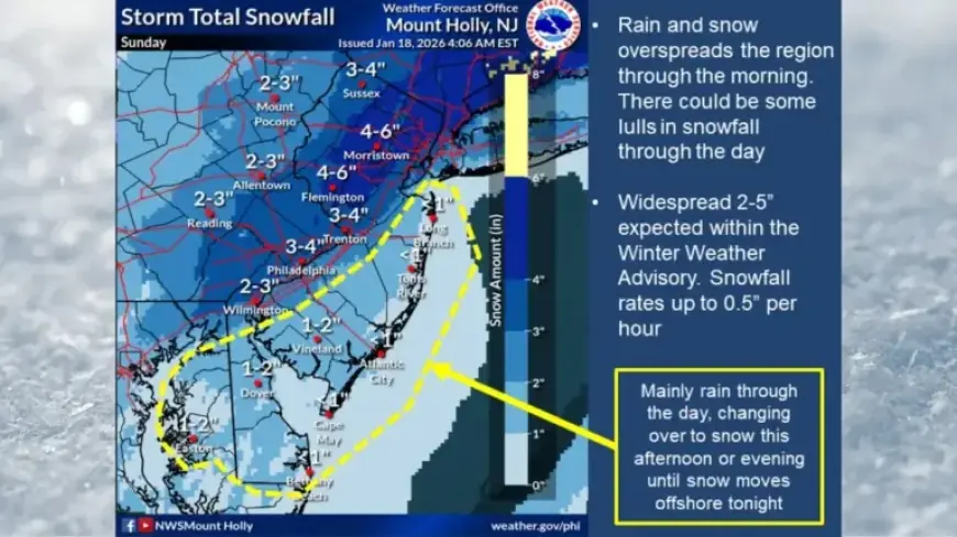
New Jersey is bracing for another winter storm expected to bring snowfall totals of 2 to 5 inches today. This follows a similar storm that impacted parts of northern New Jersey on Saturday.
N.J. Forecast: Second Weekend Storm to Bring 2-5 Inches of Snow Today
The National Weather Service (NWS) has reported that snow began falling in the early morning hours. The snowfall is expected to continue throughout the day, though there may be a break in intensity around midday. Heavier precipitation is anticipated in the afternoon.
Winter Weather Advisories Issued
Winter weather advisories have been expanded to cover 17 counties in New Jersey. Areas under these advisories will likely experience the following snowfall accumulations:
- Bergen, Essex, Hudson, Passaic, and Union counties: 3 to 5 inches until midnight.
- Camden, Gloucester, Salem, and northwestern Burlington counties: 2 to 4 inches until 8 p.m.
- Hunterdon, Mercer, Morris, Middlesex, Somerset, and western Monmouth counties: 2 to 5 inches until 8 p.m.
- Sussex and Warren counties: 2 to 4 inches until 8 p.m.
Officials note that snowfall totals have been adjusted slightly upward, particularly for areas north and west of the I-95/NJ Turnpike corridor.
Impact on Road Conditions
The NWS warns that untreated surfaces may freeze overnight as temperatures drop significantly after 7 p.m. Residents should be prepared for slick roads and hazardous travel conditions.
Cold Snap Follows the Storm
After the storm, a cold snap is expected to grip the region. Temperatures will plummet, particularly from Monday night into Tuesday night. Wind chills could approach zero degrees in some areas, creating a dangerous environment.
By Tuesday, highs are predicted to remain in the 20s, with wind chills ranging from the single digits to low teens. The bitterly cold temperatures will persist overnight, though calmer winds will reduce the severity of wind chills on Tuesday night.
Looking Ahead
An eventual warming trend is anticipated, with temperatures rising toward more seasonal averages by Wednesday. However, another cold front could bring temperatures back down or slightly below normal later in the week. Long-range forecasts suggest an active weather pattern may develop next weekend, potentially increasing the risk of snow and ice storms.
Monitoring the weather closely is essential, as predictions for upcoming winter weather remain uncertain.


