


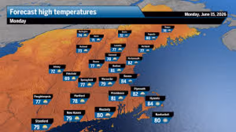
Boston is headed for a mostly sunny, cool Monday, and the dry stretch is expected to hold through Wednesday. Some clouds may linger early, but skies should turn mostly sunny by mid-morning, with low humidity and temperatures near 80 in Greater Boston.
The forecast matters because it sets up a comfortable start to the workweek across much of New England, especially for travel, outdoor plans and late-June vacation time. Greater Boston should see sunshine and temperatures near 80 on Monday and Tuesday, while suburbs dip into the 50s Monday night and downtown stays in the 60s. The rest of the region is in on the same pattern, with central and western Massachusetts expected to reach 75 to 80 on Monday and Tuesday, southeastern Massachusetts around 80, New Hampshire sunshine near 80 Monday and temperatures in the 70s Tuesday, and Rhode Island near 80 Monday with only a chance of an early shower south.
Even with the dry, comfortable weather inland, low-lying coastal areas could still deal with minor flooding at high tide Sunday night and again Monday and Tuesday evenings. That risk stretches across Massachusetts, Rhode Island, New Hampshire and southern Maine, where tide cycles can briefly push water onto roads and into the lowest shoreline spots even when the sky is clear.

Through Wednesday, the story remains simple: low humidity, temperatures in the low 80s and no rainfall. The bigger change arrives in the second half of the week, when warmer and more humid air moves back in and highs rise into the mid- to upper 80s, with a small chance of a shower around Thursday night.
The timing also works in favor of anyone hoping for a good stretch of weather. The region is on the other side of the earliest sunrise of the year and will keep gaining afternoon daylight until the summer solstice on June 21, while water temperatures continue to rise even if the ocean remains chilly, especially along the North Shore.
For now, Boston weather looks about as straightforward as a forecast gets: sun after a cloudy start, cool and dry conditions through Wednesday, and just enough coastal flooding risk to keep shoreline communities watching the tides before the warmer, stickier air arrives later in the week.


