


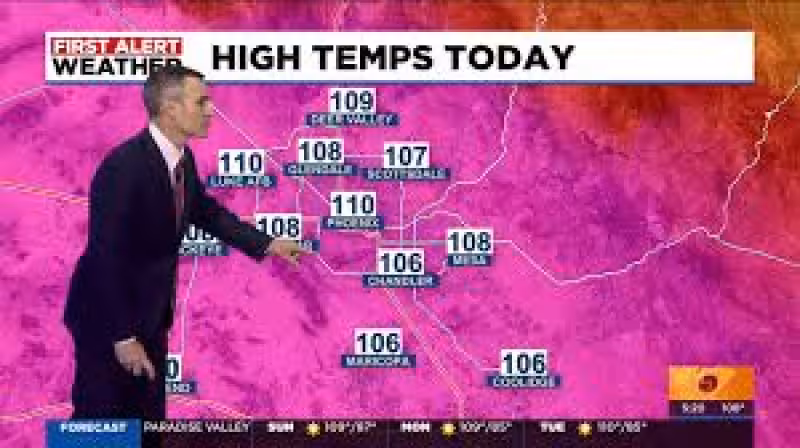
Phoenix reached its first 110-degree day of the year just before 4 p.m., and the Valley is set for more of the same over the next seven days. The city is forecast to climb back to around 109 degrees Sunday, hold near 109 on Monday and return to 110 degrees Tuesday.
That kind of heat will not break much overnight. Sunday morning temperatures in Phoenix are expected to fall only into the low 80s, and higher humidity will keep the evening quite warm. The pattern then stays hot through the middle and end of next week, with highs generally ranging from 105 to 109 degrees.
There is a little more going on than dry desert heat. Isolated showers and thunderstorms are expected to form this evening across the higher terrain north and east of Phoenix, and a few sprinkles with weakening outflow gusts could drift into the northern fringes of the Valley. Even so, Phoenix is expected to stay very hot for several more days while moisture increases nearby.


The broader regional forecast points to a changing pattern without much immediate relief. Scattered showers and thunderstorms will continue through this afternoon in the High Country before tapering off tonight, then redevelop Sunday afternoon. Storm chances rise to around 20 percent across the White Mountains on Monday and remain at 10 to 20 percent Monday night into Tuesday, while much of the rest of the mountains stays mostly dry through the week. Slight storm chances are expected to return by late next week in much of the mountains.
Tucson sits on the northern edge of the precipitation chances today, with the higher storm impacts focused in Santa Cruz and Cochise Counties. Storms south and east of Tucson have already produced gusts of 40 to 45 mph, with isolated gusts of 50 to 60 mph. In Tucson, tonight carries a 30 percent chance of showers and thunderstorms with a low around 77, followed by a 20 percent chance Monday and Wednesday and a high near 102 both days. Tuesday night is mostly clear with a low near 77 and a 20 percent chance of showers and thunderstorms, and Thursday brings a 10 percent chance of storms with a high near 100.
The immediate answer for the Valley is simple: the first 110-degree reading is here, and it is not a one-off. Phoenix is likely to hit or brush that mark again next week, while southern Arizona gets the more active storm window and the chance for gusty outflows. What remains unclear is how long the 110-degree stretch will last after next week, but for now June heat is in firm control.


