


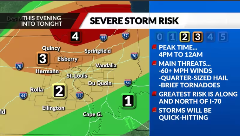
St. Louis is headed for a hot Thursday followed by a narrow window for severe storms, with the strongest weather expected to reach different parts of the region at different times. The metro area should see storms between 6 p.m. and 10 p.m., after a day that climbs into the mid-90s and pushes the heat index to 105.
The northern portion of the viewing area is under a Level 3 out of 5 risk for severe storms, while the rest of the region is at Level 2 out of 5. Communities along and north of the Interstate 70 corridor are likely to see more severe weather than those farther south, making the forecast uneven across the region even before the storms arrive.


Storms are expected to develop quickly in the late afternoon, first reaching the northwesternmost part of the viewing area between 4 p.m. and 8 p.m. They will then cross into southeast areas, including Metro St. Louis, between 6 p.m. and 10 p.m., before moving into the southeastern parts of the region between 8 p.m. and midnight. In any one spot, the storms should be quick-hitting and last only 60 to 90 minutes.
Wind is the main threat Thursday night. That matters because the day will already be oppressive before the storms arrive, and the higher-risk area does not cover the entire region equally. The southern edge of the area is less exposed than communities closer to and north of Interstate 70, even though the storm line will sweep through much of the region.
The forecast leaves one key question open: how strong the storms will be in any individual neighborhood of the metro area. What is clear is the timing. The first wave should arrive in the northwest in the late afternoon, the metro should be watching from early evening into the night, and the strongest severe-weather risk stays concentrated farther north.


