


Blizzard warnings expand as blizzard threat brings major snow, coastal flooding and emergency action
A strengthening coastal storm is set to deliver a blizzard to the Tri-State and surrounding Mid-Atlantic region, and officials have moved to limit travel and declare emergency measures as the system intensifies. The blizzard will drive heavy snow, damaging winds and coastal flooding into tonight and into Monday, with snowfall and water inundation expected to peak overnight.
Warnings, emergency declarations and travel restrictions
Every county in the region is under a Blizzard Warning, and a Blizzard Warning will go into effect on Sunday for most of the regional viewing area, including Philadelphia. A Blizzard Warning has been issued for Philadelphia, several suburban Pennsylvania counties, the entirety of New Jersey and Delaware. Gov. Sherrill declares a state of emergency for New Jersey ahead of the winter storm. New Jersey has also issued a commercial vehicle travel restriction on multiple Interstate highways starting at 3 p. m. Sunday. Drivers are urged to use caution and consider staying off the roads from Sunday evening through Monday morning as snowfall rates pick up and travel could become very difficult to impossible.
Storm mechanics, historical comparison and intensification
The storm is driven by the convergence of energy from the Ohio Valley colliding with Gulf and ocean moisture, producing a coastal system that almost resembles a winter hurricane. Forecasters say the storm will rapidly intensify through the afternoon and peak overnight and is poised to be the biggest snow-maker to slam the Tri-State since the January 2016 storm, with the last blizzard warning occurring in March 2017.
Timing, early conditions and temperature-driven changeover
Sunday morning begins with scattered light snow and rain across the region. Light precipitation is expected to begin Sunday morning, with areas northwest of Philadelphia likely beginning with light snow showers. Ground temperatures above freezing and temperatures in the mid 30s mean snow will likely initially melt as it hits the ground. Most of New Jersey is seeing rain early, and some sleet has mixed in around Ocean County before transitioning to rain. The strengthening coastal storm will tap into just enough cold air to flip rain to snow across New York City and New Jersey by midday, and after lunchtime snow becomes more widespread and significantly more intense. By evening precipitation will change over to snow for all areas as temperatures fall later in the day, and the heaviest snow is set to fall Sunday night and last into Monday morning.
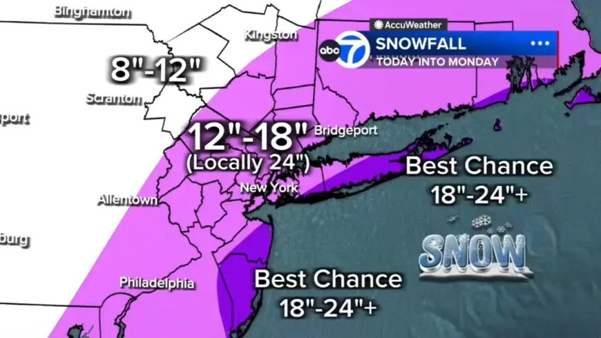
Projected snowfall, rates and regional impacts
With hours of heavy snow overnight, totals will pile up quickly. Forecasts call for 12 to 18 inches across most of the region, localized 18 to 24 inches in a central corridor from the Jersey Shore to Long Island, and the best chance for 24-plus inches on the East End of Long Island and in parts of the Jersey Shore. Coastal areas of South Jersey and Delaware are expected to see between 12 and 18 inches. Up to 12 inches is expected north and west in Pike, Sullivan and Ulster counties. Snowfall rates could reach 1 to 2 inches per hour by evening, creating whiteout or near-zero visibility conditions and a blizzard environment. Visibility is already reduced in spots, with White Plains down to 0. 2 miles, and blizzard conditions mean three or more hours of winds gusting to 35 miles an hour or greater, falling or blowing snow, and visibility less than a 1/4 of a mile; there are no requirements for the amount of snow for a blizzard designation.
Wind, coastal flooding, power and public-safety risks
Gusts of 50 to 60 mph are possible near the coast, and gusty winds could bring down tree branches and result in isolated or widespread power outages from downed trees and lines. Winds whipping off the ocean will push water inland, with up to 3 feet of coastal inundation possible around high-tide cycles tonight into Monday morning, especially along Long Island and the Jersey Shore. The posted alert for Sunday into Monday warns of heavy snow, blizzard conditions, high winds, coastal flooding and beach erosion. By Monday morning heavy snow should begin tapering off from west to east as the coastal storm continues to strengthen and move away, with improving conditions by mid-morning and snow tapering in the second half of the day, though winds will remain strong and travel will still be impacted.