


Philadelphia Weather: Blizzard Warning Expands, Residents and Commuters Face Severe Disruptions
Why this matters now: philadelphia weather will shift from rain and mixed showers to a full blizzard threat Sunday evening, bringing very difficult travel conditions for city residents and commuters first. Gusty winds that can topple tree branches, isolated power outages and coastal flooding risk raise the stakes for anyone planning to be on the roads from Sunday night into Monday morning. Here’s the part that matters: plan to stay off the roads if possible.
Philadelphia Weather — immediate impacts and who feels them first
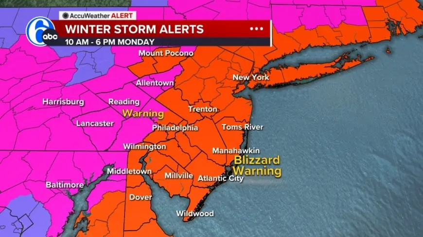
The expanded Blizzard Warning now includes Philadelphia, several suburban Pennsylvania counties, and the entirety of New Jersey and Delaware. The first people affected will be drivers and anyone outdoors as precipitation transitions from rain to snow late Sunday; coastal communities should also expect increased risk from coastal flooding and beach erosion tied to high winds and the strengthening coastal storm.
Storm timing, warning area and what a blizzard means
The heaviest snow is set to fall Sunday night and will last into Monday, with light precipitation beginning Sunday morning and heavier rates overnight. A weather alert is posted for Sunday into Monday for heavy snow, blizzard conditions for most of the area, high winds, coastal flooding and beach erosion.
- Warning area: Philadelphia, multiple suburban Pennsylvania counties, all of New Jersey and Delaware.
- Definition reminder: a blizzard is three or more hours of winds gusting to 35 miles an hour or greater, falling or blowing snow, and visibility less than a quarter mile. There is no required amount of snow for a blizzard declaration.
- Micro timeline:
- Sunday morning — light precipitation begins; northwest areas likely start with light snow showers.
- Sunday evening/night — temperatures fall and precipitation changes to all snow; heaviest snow overnight.
- Monday morning — snow begins tapering off west to east as the coastal storm moves away.
Forecast specifics: temperatures, precipitation type and snowfall pockets
On Sunday it will be cloudy and cooler with rain and snow showers developing and a high near 39 degrees. Ground temperatures above freezing and air temperatures in the mid 30s mean initial snow may melt on contact in places; as temperatures fall later in the day, mixed precipitation and rain will change over to snow for all areas. Timing of the heaviest overnight snow creates ideal conditions for accumulation.
Coastal areas of southern New Jersey and Delaware are expected to receive between 12 and 18 inches of snow as the storm strengthens. Drivers and residents in and around Philadelphia should expect a mix of rain and snow earlier, with rain showers more likely south and east of the city before the changeover.
- Light precipitation begins Sunday morning; northwest of the city likely to see early snow showers.
- Temperatures hover in the mid 30s before falling late Sunday, increasing accumulation potential.
It’s easy to overlook, but an ordinary-looking Sunday afternoon could become hazardous by evening once winds pick up and visibility drops sharply.
Safety guidance, travel advisories and likely impacts
When blizzard conditions develop, travel could be very difficult to impossible as blowing snow severely reduces visibility. Gusty winds could bring down tree branches and result in isolated power outages. Drivers are urged to use caution and consider staying off the roads from Sunday evening through Monday morning while snowfall rates pick up.
- Drivers: consider avoiding travel Sunday evening through Monday morning unless essential.
- Coastal residents: prepare for high winds, coastal flooding and potential beach erosion.
- Property risks: falling tree branches and isolated outages are possible during high winds.
The real question now is how quickly the coastal storm will strengthen and how that will affect the timing of tapering; early Monday the snow should begin winding down from west to east as the storm moves away.
Key takeaways
- A Blizzard Warning is now in effect for Philadelphia and large parts of the region; expect the heaviest snow Sunday night into Monday.
- philadelphia weather will shift from mixed rain/snow to all snow as temperatures fall late Sunday.
- Definition: blizzard conditions require sustained gusts of 35 mph or more, falling/blowing snow and visibility under 1/4 mile; total snowfall amount is not part of that definition.
- Coastal South Jersey and Delaware could see 12–18 inches; inland areas should prepare for significant accumulation once the changeover completes.
- Plan for dangerous travel conditions, possible downed branches and isolated power outages during high winds.
What’s easy to miss is the combination of timing and temperature: heavy snow arriving overnight, once air and ground temperatures drop, increases the chance of rapid accumulation and severely reduced visibility.