


National Weather Service issues winter storm warnings as nor'easter targets DC, Maryland and Virginia
The national weather service has issued Winter Storm Warnings and watches as a nor'easter pushes rain into the mid-Atlantic Sunday before changing to snow Sunday night into Monday, threatening several inches of accumulation and hazardous travel.
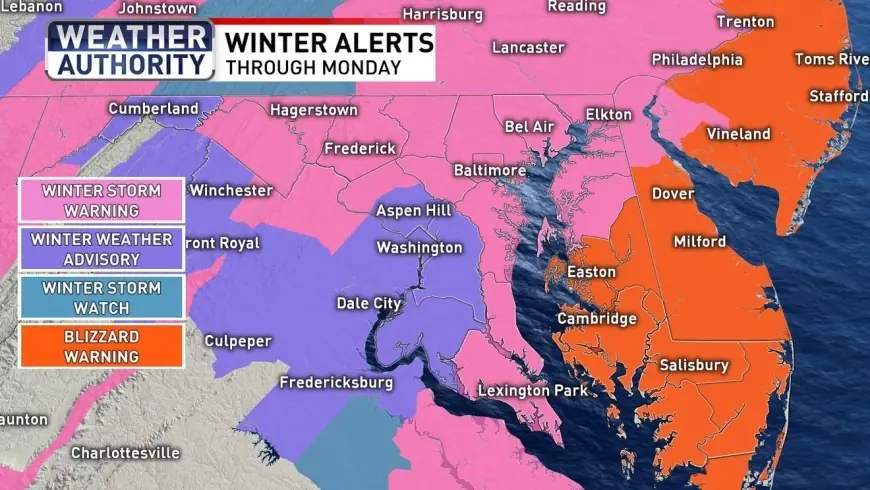
National Weather Service warnings cover the DC metro and much of Maryland
Updated February 21, 11: 45 p. m., the forecast shows the storm bringing heavy rain across the Baltimore and Washington metros before temperatures fall and precipitation turns to snow. Winter Storm Warnings are posted across much of Maryland, with blizzard warnings along parts of the Eastern Shore and Delaware beaches where 10 inches or more is possible alongside 40-mph wind gusts. The I-95 corridor is most likely to see 3–6 inches of snow, while totals will be higher in northeastern Maryland and the Eastern Shore.
Storm track and snowfall expectations
The national weather service projected the District could pick up about 3. 4 inches of snow by 1 a. m. Tuesday, with higher amounts to the north and east: 5. 4 inches in Leesburg, 8. 6 inches in Annapolis and 14. 1 inches in Elkton. Little accumulation is expected during the first half of Sunday because of warm ground temperatures; measurable snow is forecast mainly Sunday night through early Monday, with blowing snow and reduced visibility a concern during peak snowfall.
Local preparations, closures and coastal impacts
Officials have mobilized road crews and begun pretreatment plans: salt treatment of major District roadways is scheduled to begin at noon Sunday, and county crews will mobilize at noon as well. A county advisory notes TheBus will not run on Sunday and free parking will be made available in county garages through at least noon Monday. The governor declared a State of Preparedness, and the city opened hypothermia shelters as temperatures fall.
Gale Watches are in effect for the Chesapeake Bay and nearshore coastal waters for Sunday evening into early Monday afternoon, with northerly winds expected to increase to 25–35 knots and gusts up to 40–45 knots. Minor tidal flooding is possible late Sunday night into early Monday along portions of Maryland beaches, with inundation up to one foot in vulnerable areas.
Roads are expected to become slick Sunday night as rain shifts to snow and visibility drops. Crews cautioned that pretreatment efforts could be limited while rain continues; one transportation spokesman advised residents to stay home if possible on Sunday to allow crews to get roads cleared once precipitation turns to snow.
After the storm, temperatures should remain cool. Highs will reach the upper 30s Monday with breezy conditions and wind chills in the 20s. Tuesday will be chilly with highs in the mid 30s, and by midweek temperatures are forecast to climb into the upper 40s and low 50s, which will begin to melt accumulated snow. The next chance of rain is scheduled for Thursday.
The immediate, confirmed milestones are pretreatment and salt operations beginning at noon Sunday and a Winter Storm Warning in effect from 3 p. m. Sunday through 10 a. m. Monday, with crews and emergency services standing by as the nor'easter moves through the region.