


Philadelphia Weather: Blizzard Warning expanded; now includes Philadelphia, philadelphia weather live updates
philadelphia weather is under a Blizzard Warning that will go into effect on Sunday for most of the 6abc viewing area, and that now includes Philadelphia. The heaviest snow is set to fall Sunday night and will last into Monday.
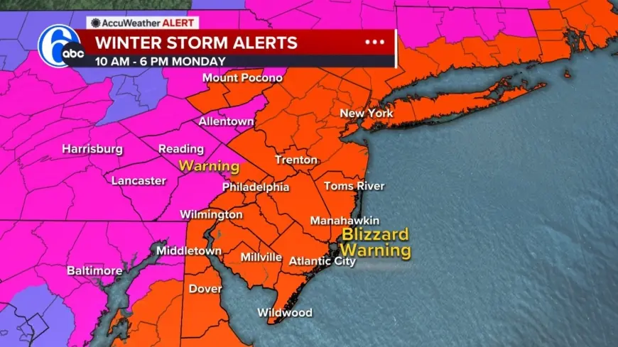
Philadelphia Weather Outlook
An AccuWeather Alert is posted for Sunday into Monday for heavy snow, blizzard conditions for most of the area, high winds, coastal flooding and beach erosion. A Blizzard Warning has been issued for Philadelphia, several suburban Pa. counties, along with the entirety of New Jersey and Delaware. The notice originates from WPVI coverage of the situation.
What the Blizzard Warning Means
A blizzard means three or more hours of winds gusting to 35 miles an hour or greater, falling or blowing snow, and visibility less than a 1/4 of a mile. There are no requirements for the amount of snow when it comes to a blizzard. When blizzard conditions develop, travel could be very difficult to impossible as areas of blowing snow could significantly reduce visibility. Gusty winds could bring down tree branches and result in isolated power outages.
Timing, Temperatures and Changeover
Light precipitation is expected to begin Sunday morning. Areas northwest of the city will likely begin with light snow showers. With ground temperatures above freezing and temperatures in the mid 30s, snow will likely initially melt as it hits the ground. On Sunday it will be cloudy and cooler with rain and snow showers developing and a high near 39 degrees. As temperatures drop later in the evening, any rain or mixed precipitation will change to snow for all areas; the timing of the heaviest snow overnight leads to ideal conditions for accumulation.
Travel, Roads and Safety
Drivers are urged to use caution and consider staying off the roads from Sunday evening through Monday morning as snow continues and snowfall rates pick up. When blizzard conditions develop, travel could be very difficult to impossible. Gusty winds could bring down tree branches and result in isolated power outages. All schools and offices will operate virtually on Monday, February 23.
Coastal Impacts and Snowfall
The storm is expected to bring between 12 and 18 inches of snow to coastal areas of South Jersey and Delaware. Other assessments in the coverage indicate up to a foot of snow to hit Philly and up to 20 inches to hit New Jersey. A mix of rain and snow is expected around Philadelphia, with rain showers for areas south and east. By Monday morning, snow will begin tapering off west to east as the coastal storm continues to strengthen and move away from the coast.
The situation combines heavy snow, blizzard conditions, high winds, coastal flooding and beach erosion across the region from Sunday into Monday; residents should prepare for dangerous travel, potential isolated power outages and significant coastal impacts.