


Blizzard Warning: blizzard warning expanded as NYC, Tri-State face major East Coast storm
A dangerous and potentially historic winter storm is set to slam the Tri-State area later today, and a blizzard warning covers every county in the region. The blizzard warning comes as the system is expected to intensify through the afternoon, peak overnight and produce heavy snow, damaging winds and coastal flooding.
Storm timing and setup
The morning begins with scattered light snow and rain, but the storm will rapidly intensify through the afternoon and peak overnight. Energy from the Ohio Valley is colliding with Gulf and ocean moisture, creating a system that almost resembles a winter hurricane. That setup will allow the strengthening coastal storm to pull up the East Coast and tap into just enough cold air to flip rain to snow across New York City and New Jersey by midday.
Blizzard Warning across region
Every county in the region is under a Blizzard Warning. The last time the area faced a blizzard warning was in March 2017, making this a rare event. Forecasters say this storm is poised to be the biggest snow-maker to slam the Tri-State area since the storm of January 2016, which was the biggest snowstorm to ever hit NYC on record.
Where precipitation is falling now
Light snow is falling across Sullivan, Ulster, Dutchess, Orange, and parts of northwest New Jersey, while most of New Jersey is seeing rain early. Some sleet mixed in around Ocean County before transitioning to rain. Roads begin the day wet, which may delay initial snow accumulation, but that delay is expected to be brief. Visibility is already reduced in spots, with White Plains down to 0. 2 miles, and travel is expected to grow increasingly difficult as heavier snow organizes later today.
Evening into overnight threats
After lunchtime, snow becomes more widespread and significantly more intense. By evening, heavier bands will develop and conditions will deteriorate rapidly. Forecast impacts for the worst conditions tonight include snowfall rates of 1 to 2 inches per hour, wind gusts 50 to 60 mph near the coast, whiteout visibility and widespread power outage potential due to downed trees and lines.
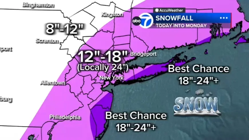
Expected snow totals and coastal flooding
With hours of heavy snow overnight, totals will pile up quickly. Most of the region is forecast to see 12 to 18 inches. A localized central corridor from the Jersey Shore to Long Island could receive 18 to 24 inches. The best chance for 24-plus inches is on the East End of Long Island and parts of the Jersey Shore. Areas north and west — including Pike, Sullivan and Ulster counties — could see up to 12 inches. Winds whipping off the ocean will push water inland, with up to 3 feet of coastal inundation possible around high-tide cycles tonight into Monday morning, especially along Long Island and the Jersey Shore.
Hour-by-hour expectations
This morning: light mix with mainly wet roads and visibility issues in spots. Afternoon: rain changes to snow for NYC and New Jersey, with intensity increasing after lunchtime. Tonight (worst conditions): widespread heavy snow with 1 to 2 inch per hour snowfall, 50 to 60 mph gusts at the coast, blizzard conditions with near-zero visibility, and a significant power outage risk. Monday morning: heavy snow continues through the early morning, with improving conditions by mid-morning; snow is expected to taper the second half of the day, but winds will remain strong and travel will remain impacted.
Restrictions and public safety
New Jersey has issued a commercial vehicle travel restriction on multiple Interstate highways starting at 3 p. m. Sunday. Motorists should expect travel disruptions and widespread impacts to power and visibility as the storm progresses.
Major East Coast Storm Expected Sunday, Monday will bring a mix of heavy snow, damaging winds and coastal flooding to the region; the blizzard warning remains in effect and conditions are expected to worsen through tonight.