


Blizzard Warning: Major East Coast Storm Expected Sunday and Monday as Tri-State Braces
The Tri-State area is staring at an event that will immediately affect travel, power and the hardest-hit neighborhoods: a blizzard warning is in effect and the storm is expected to produce sustained, damaging conditions Sunday night into Monday. Meteorologist Jeff Smith warns this could be one of the region's most significant snowstorms in years, with the strongest impacts concentrated where heavy bands stall.
Blizzard Warning: the direct impacts households and commuters face
Here’s the part that matters: heavy, wet snow combined with high winds raises the risk of downed trees and widespread power outages, while roads are likely to become impassable. Road conditions will deteriorate rapidly Sunday evening and the Monday morning commute may be impossible in some areas. Emergency managers and households should expect extended outages where gusts and heavy snow coincide.
Storm mechanics and how the system will intensify
The storm forms as energy from the Ohio Valley collides with Gulf and ocean moisture, creating a system that almost resembles a winter hurricane. Conditions are expected to be quiet Saturday evening before clouds thicken overnight; a few rain or snow showers may appear early Sunday while temperatures remain above freezing to start the day. By midday Sunday visibility will begin dropping as steadier snow develops, especially from New York City south and west. After sunset temperatures fall and the storm rapidly intensifies offshore, pulling heavy snow bands directly into the region.
Projected snowfall, wind and which neighborhoods are at greatest risk
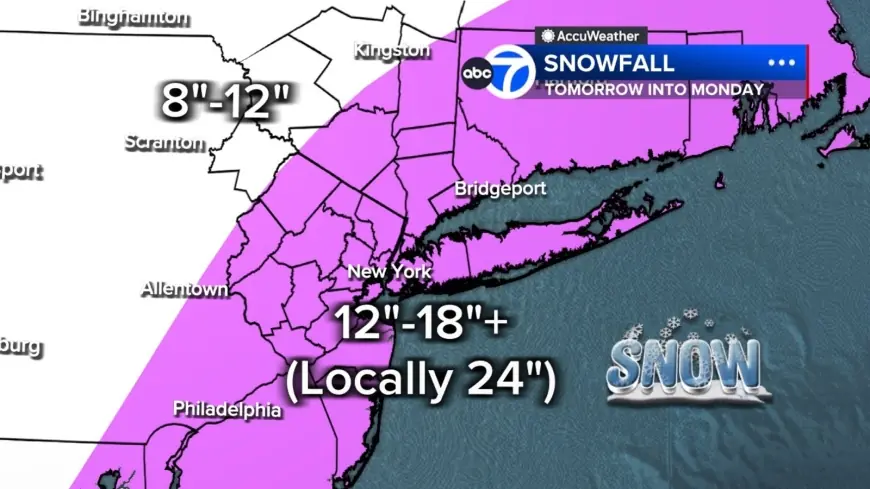
- Most of the region is projected to see 12 to 18 inches of snow, with localized totals up to 24 inches or more where the heaviest bands stall.
- Long Island and parts of the Jersey Shore have the highest likelihood of those extreme totals; farther north and west, including the Poconos and Catskills, amounts are expected to be lower (roughly 8 to 12 inches) due to less access to the storm's core moisture.
- Snow bands could drop 2 to 3 inches per hour and in some places may sit overhead for hours.
- The storm meets full-blown blizzard criteria: winds gusting 35 mph or higher, heavy snow, and visibility under a quarter mile for at least three consecutive hours; the area may see 10 to 12 hours of true blizzard conditions Sunday night into Monday.
- Winds will rise throughout Sunday, peaking overnight with gusts over 40 mph across the region and potentially up to 60 mph on Long Island.
Travel, infrastructure and airline operations
Dangerous travel and the potential for widespread power outages are expected. Combined with wet, heavy snow, those winds create a significant risk for downed trees and outages. American Airlines will suspend operations at LaGuardia, JFK and Philadelphia beginning Sunday afternoon through the day Monday because of the blizzard; teams are preparing to resume operations at the affected airports on Tuesday, Feb. 24 as soon as conditions allow airlines to do so safely.
Timing, tapering and what follows
Snow should gradually taper Monday afternoon, though gusty winds and scattered blowing snow will continue. Tuesday will turn colder and breezy with leftover cleanup underway. Another system is possible Wednesday, but early indications suggest it will be significantly weaker. Check back for frequent live updates as conditions evolve and local offices issue guidance.
- Most urgent: expect the worst of conditions Sunday night into Monday, with 10 to 12 hours of blizzard conditions possible.
- If you travel: anticipate rapid deterioration Sunday evening and the likelihood that Monday morning commutes will be impossible in some places.
- Power risk: wet, heavy snow plus gusts (over 40 mph regionally; up to 60 mph on Long Island) increase odds of downed trees and outages.
- Airlines: key airport operations are suspended beginning Sunday afternoon through Monday, with a planned restart on Tuesday, Feb. 24 when safe.
The real question now is how long localized extreme bands will park over the same neighborhoods; where they stall determines whether totals hit 24 inches or remain closer to the regional forecast. It’s easy to overlook, but timing of the offshore intensification after sunset will be the primary factor that controls who gets the heaviest snow.
Stay tuned for live updates; check back frequently as forecasts refine exact band placement and timing.