


Snowfall Weather Forecast: Warnings for Snow, Heavy Rain and Ice as Cold Snap Continues
Forecasters have put large swathes of the UK under yellow warnings for snow, rain and ice as a cold snap driven by north-westerly winds keeps temperatures low. The snowfall weather forecast is central to travel and flood planning over the next 48 hours because heavy rain and strong winds are combining with hill snow to create multiple hazards.
Met Office Warnings and UKHSA Cold Alert
The Met Office has issued yellow warnings covering parts of England, Wales and Northern Ireland, with national severe weather notices remaining in force until Thursday morning. The UK Health Security Agency has an active cold weather alert covering most of England until 18: 00 GMT on Friday after north-westerly winds pushed temperatures down across the country.
Northern Ireland and the Sperrins
Northern Ireland saw a yellow warning for rain and snow come into force early on Wednesday, and forecasters expect a mix of wet and wintry weather through the day. Persistent rain is likely at low levels while snow will fall over high ground, especially the Sperrins, where several centimetres could accumulate above around 250 metres. Strong southeasterly winds will accompany the band of precipitation, and any lying snow is expected to thaw during the evening and overnight.
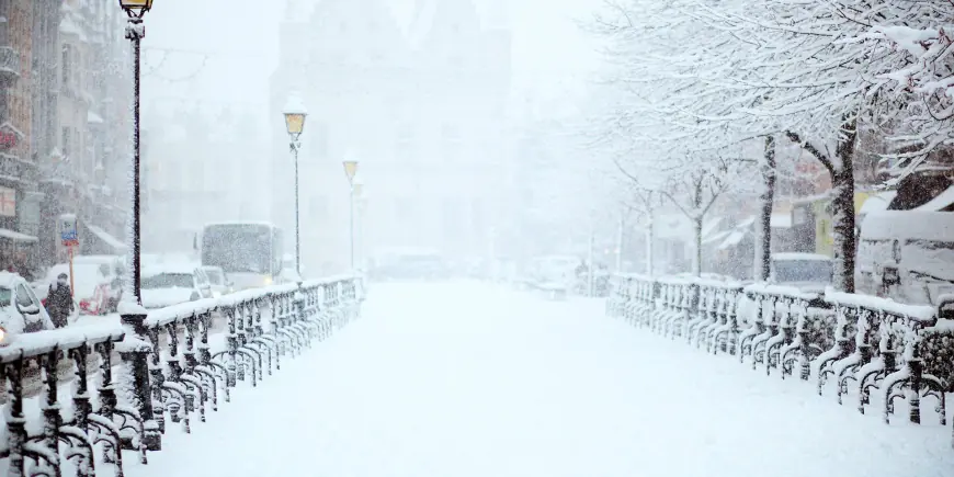
Snowfall Weather Forecast: Accumulations Above 150–300 Metres
Models indicate several centimetres of snow are likely over high ground above roughly 150–200 metres, with varying estimates for higher elevations. One set of figures indicates snowfall of 2–5 cm above 150–200 metres, with 10–15 cm possible above 250–300 metres across mid and south-east Wales, Herefordshire, Shropshire and the southern Pennines. Elsewhere, the highest ground in mid and south-east Wales was also flagged as having the potential for up to 15 cm in another assessment, while residents on higher ground in mid and south-east Wales have been warned they could see as much as 20 cm (8 in) of snow in places.
Southern England, Dartmoor and Coastal Impacts
Southern counties face heavy rain through Wednesday into Thursday, with many areas expected to see 10–20 mm. Local totals of 20–30 mm are possible along the south coast and up to 50 mm have been forecast for Dartmoor. The band of rain will be accompanied by strong east to northeasterly winds and the potential for large waves on some east-facing coasts, particularly along the English Channel. These rainfall totals—local peaks of 30–50 mm in the wettest places—could worsen flooding in areas already affected earlier in 2026.
Wales: 18 Counties Under Yellow Warnings
A yellow warning that covers 18 counties in Wales runs through the early hours of Thursday, with snow expected until 06: 00 GMT and an ice warning in the same area in effect until 10: 00 GMT. The counties named include Blaenau Gwent, Bridgend, Caerphilly, Carmarthenshire, Ceredigion, Conwy, Denbighshire, Gwynedd, Merthyr Tydfil, Monmouthshire, Neath Port Talbot, Newport, Pembrokeshire, Powys, Rhondda Cynon Taf, Swansea, Torfaen and Wrexham. Forecasters have warned of travel disruption, the possibility of rural communities becoming cut off and a small chance of power and mobile service cuts, driven in part by strong winds.
Chief Forecaster Jason Kelly’s Guidance and Wider Outlook
Chief Forecaster Jason Kelly highlighted the potential for rain, sleet and snow to affect parts of Wales, central England and the southern Pennines from Wednesday evening into early Thursday, and noted that strong east to northeasterly winds could increase impacts. He set out expected snowfall ranges—small amounts at lower levels and larger accumulations on higher ground—and cautioned that falling temperatures overnight will raise the risk of ice. As the system clears on Thursday many areas should turn drier, though Northern Ireland and western Scotland will see cloud and rain increase by the afternoon. The weekend outlook remains unsettled with further bands of rain and an increasing influence of milder Atlantic air, which could push daytime highs up to around 16°C in sheltered spots before a return nearer to average next week.
Local Consequences: Travel, Power and Infrastructure
Direct effects of the forecasted conditions include a risk of travel delays from stranded vehicles, interruptions to train and flight schedules, and the slight possibility that some rural communities could be isolated by deep snow. Wind gusts of 45–55 mph were highlighted as an additional hazard in areas exposed to strong gusts. The wintry mix at lower levels—rain, sleet and occasional wet snow—could make driving difficult on Wednesday evening into the night and create a small chance of power cuts. What makes this notable is the convergence of heavy rain, hill snow and strong winds over the same 24–48 hour period, increasing the chance that multiple impacts occur simultaneously.
Unconnected Local Notices
Separately, a railway closure has been explained as part of engineering works on the line taking place over the school half-term break. Deputy Lyndon Farnham has urged Jersey and Guernsey to "find solutions" to inter-island travel. Local grants have been allocated to educational institutions—Vauvert School, the Sixth Form Centre and Ladies College will share £3, 000—and a city council’s landscaping proposals could see 49 new trees planted as part of a local project. These local measures and works are continuing alongside the current weather warnings.