


Fire Weather Watch and Red Flag Alerts Put Central West Florida Communities on Notice as Drought Persists
Who feels this first: residents, land managers and anyone outdoors in Central West Florida are facing an elevated fire threat over the next several days. The region is under a Fire Weather Watch for Monday and a red flag warning for Sunday as gusty winds, low humidities and expanding areas of extreme drought combine to raise the chance that any ignition could spread rapidly. Take local burn bans and outdoor cautions seriously.
Immediate impact on people and property: who should change plans now
Here's the part that matters: outdoor activity that involves flames, sparks or discarded smoking materials is riskier than usual. The red flag warning for Sunday and the Fire Weather Watch for Monday both point to the same drivers — dry ground and gusty winds — so people who planned yard work, debris burning or grilling should postpone, check for burn bans and be ready to act quickly if a fire starts.
- Sunday will see much cooler, breezy conditions behind a front, with highs in the 60s and evening lows in the 30s and 40s.
- Monday is expected to be the coolest day of the week with morning temperatures near 40 and daytime highs in the low to mid 50s under a northerly flow.
- Widespread frost or freeze is likely Tuesday morning with lows in the 20s and 30s; wind will make it feel like the 20s across most of the area.
- Short-term rainfall from the approaching front is light — generally under a tenth of an inch — and later-week precipitation looks minimal, so drought conditions are unlikely to improve immediately.
What’s easy to miss is how the drought signal amplifies every small ignition risk: dry fuels plus gusty winds shorten the time to suppression and widen the area a spark can reach.
Fire Weather Watch: where and when it applies
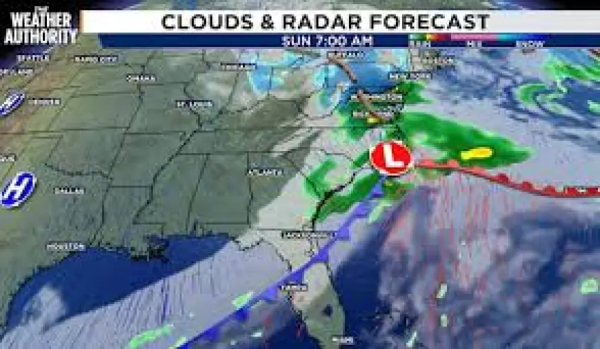
A Fire Weather Watch is in effect for Monday for parts of Central West Florida. On top of that, a red flag warning has been issued that is valid Sunday from 1 p. m. to 7 p. m. The red flag applies specifically to Coastal Levy and Inland Levy counties, as well as Citrus, Hernando and Sumter counties. Expect northwest winds of 10 to 15 mph with gusts up to 25 mph and relative humidities that can drop to about 28 percent during the warning window.
Official safety steps and practical precautions
During the red flag period, exercise extreme caution and be prepared to take immediate action if a fire starts. Recommended precautions include ensuring authorized burn barrels have a weighted metal cover with holes no larger than 3/4 of an inch; never discarding lit cigarette butts or matches (and never throwing them from a moving vehicle); and fully extinguishing outdoor fires by drowning with water and stirring until everything is cold to the touch. Submerge charcoal until it is thoroughly cooled and never dispose of live charcoal on the ground. Avoid abandoning any fire without supervision.
Short-range forecast, drought status and timing details
Cloud cover will increase tonight and temperatures will be mild for this time of year, with overnight lows in the 50s and 60s. A front will bring a few showers overnight through Sunday morning, though activity is expected to be limited and rainfall totals generally under a tenth of an inch. Behind that front, Sunday will be cooler and breezy with a mostly cloudy sky and highs in the 60s; official Sunday forecast numbers show a high of 68 and a low of 34. Wednesday is projected to be mostly sunny with a high near 70 and a low near 45.
The drought monitor reflects a persistent multi-week pattern: the area categorized as extreme drought has continued to expand week to week and now covers most of the local area. Another front could approach later in the week, but expected rainfall accumulation looks minimal and not enough to end the drought in the near term.
Context on coverage and reporting
At 12: 23 p. m. on Saturday a red flag warning was issued and set the 1 p. m. to 7 p. m. Sunday window described above. A separate regional piece noted Central West Florida under a fire weather watch Monday with gusts up to 25 mph. Some published items were produced using artificial intelligence and publicly available data; an article template used for those automated pieces was created by a regional paper (name redacted). Reader discussions are limited — anyone can view recent comments, but contributing typically requires a subscription to the regional paper's e-newspaper product. For public-file assistance connected to local broadcast operations, a contact line is available at 393-9801; for feedback on automated weather items, an editorial feedback address was listed as weather-feedback@tampabay. com.
Chris Holtzman, who joined the local station in October 2025, is identified as a member of the American Meteorological Society and as a Certified Broadcast Meteorologist designated by that society.
The real question now is how quickly fuel moisture and any late-week precipitation change the fire threat; in the absence of meaningful rainfall, elevated risk will persist into next week.