


Blizzard Warning: blizzard warning issued as storm could be biggest in decade
A blizzard warning is in effect as a powerful winter storm is set to slam New York City and the Tri-State area Sunday night into Monday, bringing blizzard conditions, dangerous travel and the potential for widespread power outages. Meteorologist Jeff Smith said the system could rank among the most significant snowstorms the region has seen in years.
Blizzard Warning areas and timing
Blizzard Warnings are in effect for Long Island, all five boroughs, Westchester and Rockland counties, coastal Connecticut and much of New Jersey. Separate blizzard warnings have been issued for 17 counties in New Jersey, and the blizzard warnings and winter storm warnings for the four remaining counties run through 6 p. m. Monday. The area may see 10 to 12 hours of true blizzard conditions Sunday night into Monday.
Snow totals and wind forecasts
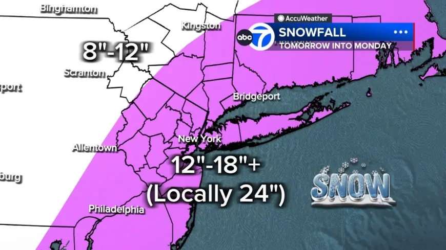
Most of the region is projected to see 12 to 18 inches of snow, with localized totals up to 24 inches or more where the heaviest bands stall. Widespread snowfall totals of 12 to 18 inches are expected across New Jersey, with the highest totals nearing 2 feet forecast for Monmouth, Ocean and southeastern Burlington counties. East of the I-95 corridor across much of central and southern New Jersey, amounts exceeding 18 inches are expected and isolated totals as high as 24 inches are possible. Farther north and west, including the Poconos and Catskills, amounts will be lower, roughly 8 to 12 inches, because those areas have less access to the storm's core moisture.
Snowfall rates could reach 2 to 3 inches per hour in heavy bands and the National Weather Service warned that snowfall rates could exceed 2 inches per hour where the heaviest accumulations are forecast. Bands of snow may sit overhead for hours.
The storm meets blizzard criteria of winds gusting 35 mph or higher, heavy snow and visibility under a quarter mile for at least three consecutive hours. Winds will increase through Sunday and peak overnight, with gusts over 40 mph across the region, potentially up to 60 mph on Long Island. In New Jersey the warnings note wind gusts up to 55 mph possible, and in some coastal areas winds gusting as high as 50 mph have been forecast.
Coastal flood and county warnings
Moderate coastal flooding along the Jersey Shore and Delaware Bay is a concern. Coastal flood warnings are in effect for Atlantic, Cape May, Middlesex, Monmouth, Ocean and southeastern Burlington counties from 9 p. m. Sunday to 5 a. m. Monday. For Atlantic and Cape May counties a separate coastal warning runs from 1 p. m. Sunday to 6 p. m. Monday; total snow accumulations there are expected between 12 and 20 inches with winds gusting as high as 50 mph.
Closures, emergencies and travel advisories
Gov. Mikie Sherrill declared a state of emergency for all 21 New Jersey counties ahead of the storm, effective at noon on Sunday. "I am urging you to stay off the roads Sunday through Monday, " Sherrill said during a Saturday afternoon press conference. "The heaviest snowfall is expected between Sunday night and Monday morning. " Widespread travel disruptions are likely Sunday evening and well into Monday, and school closures and schedule changes are expected in many districts.
Paterson Public Schools will be closed on Monday, February 23, 2026. All after-school programs are cancelled and recreation programs will remain closed until further notice.
Storm timeline and expected impacts
The storm is driven by the convergence of energy from the Ohio Valley colliding with Gulf and ocean moisture, producing a system that in some ways resembles a winter hurricane. Conditions should remain quiet Saturday evening before clouds thicken overnight. A few rain or snow showers may pop up early Sunday while temperatures remain above freezing to start the day; the storm could start as light rain in much of the state early Sunday before transitioning to snow by late morning or early afternoon. By midday Sunday visibility will begin dropping as steadier snow develops, especially from New York City south and west. After sunset temperatures will fall and the storm will rapidly intensify offshore, pulling heavy snow bands directly into the region.
Officials warn that the wet, heavy snow combined with high winds will put a strain on trees and power lines, creating a significant risk for downed trees and extensive power outages. "The clinging nature of the snow and high winds will put a strain on trees and power lines, with extensive power outages anticipated, " AccuWeather Meteorologist Alex Duffus said. Road conditions are expected to deteriorate rapidly Sunday evening, and the Monday morning commute may be impossible in some areas. Snow will gradually taper Monday afternoon, though gusty winds and scattered blowing snow will continue. Tuesday will turn colder and breezy as cleanup continues, and another system is possible Wednesday but early indications suggest it will be significantly weaker.
The blizzard warning remains active; residents should plan for heavy, wet and sticky snow, potential whiteouts from blowing snow and limited travel during the peak Sunday night into Monday.