


Noaa Weather: Heavy Snow Risk Zone Expands as Models Diverge on Maryland Storm Track
The latest noaa weather outlook shows an expanding heavy-snow risk across parts of Maryland and Virginia as forecasters wrestle with divergent model guidance ahead of a Sunday into Monday coastal storm. The updated guidance raises the odds of measurable snow in the Washington region while keeping the possibility of a major event low but not eliminated.
What happened and what’s new
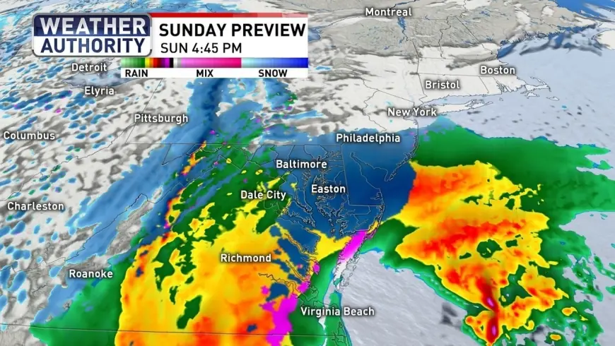
The National Weather Service Weather Prediction Center released an updated hazards outlook that places portions of Maryland within a designated "Heavy Snow" risk area as forecasters continue to monitor a low pressure system projected to intensify off the Mid-Atlantic coast late Sunday into Monday. Model guidance remains discordant on storm strength and track, and that disagreement is driving a wide range of potential outcomes.
- Forecast model outputs span a broad envelope: one global model indicates a high-impact but low-confidence scenario with snowfall potentially reaching two feet, while another continental model suggests a more restrained event with accumulations up to six inches.
- A multi-model blend that updates frequently is showing a middle-ground solution near five inches at the time of the latest update on 7: 00 a. m. February 20.
- Current consensus portrays an early Sunday rain/snow mix transitioning to wet snow Sunday evening into Monday morning, with most accumulation expected after sunset when ground temperatures are lower following warmer daytime conditions leading into the system.
- Ensemble guidance indicates a high probability—above 90 percent in some measures—of at least some snow in the Washington region. The odds of a disruptive snowfall of two inches or more for the DC area have risen to just above 50 percent, while the chance of eight inches or more sits near 10 percent.
- The heavy-snow threat area was expanded southward in the outlook to include portions of coastal Virginia, broadening the zone under consideration for impactful snowfall.
- Impacts are expected to linger into Monday morning, with the potential for delays driven by below-freezing temperatures and slick surfaces.
Behind the headline: Noaa Weather context and stakeholders
The current guidance reflects a common meteorological challenge: relatively consistent synoptic setup but low confidence in mesoscale details that determine how far inland heavier snow will push. The interaction between southern and northern jet stream features and the timing of coastal intensification are the crucial variables. That uncertainty constrains decision-making for state and local officials, transportation agencies, schools, and businesses that must weigh preparations now against the possibility of over- or under-reacting as the system evolves.
What we still don’t know
- Exact storm track and how far west heavier snow will reach.
- Final snowfall totals at county and neighborhood scales.
- Timing of the rain-to-snow transition in inland locations.
- How ground temperatures and daytime warmth prior to the event will affect accumulation and stickage.
- Potential for localized higher-end snowfall within the broad modeled ranges.
What happens next
- Convergent-track scenario: If the coastal low trends slightly inland, higher-end snowfall accumulations could materialize across central and eastern Maryland and portions of Virginia, prompting travel disruptions and precautionary closures—trigger: model runs trending northward.
- Offshore scenario: If the low stays farther offshore, precipitation may remain lighter and more mixed, yielding only minor accumulations—trigger: successive model runs favoring a southern/offshore solution.
- Split-ensemble outcome: Ensembles maintain a wide spread, producing a patchwork of conditions with heavier snow in localized corridors and mixed precipitation elsewhere—trigger: continued high ensemble spread in late model guidance.
- Rapid amplification: If phasing of jet stream features enhances coastal intensification at the right time, a sharper uptick in snowfall potential could occur—trigger: model indications of phasing and rapid deepening of the coastal low.
- Cold-surface impact: Even modest snowfall could create travel issues if below-freezing temperatures persist into Monday morning, extending impacts—trigger: forecasts showing subfreezing surface temperatures overnight into Monday.
Why it matters
The practical implications are near-term and localized: travel plans and school or workplace operations may require adjustment based on final forecasts, and transportation agencies will need to balance pre-staging resources against uncertainty. For commuters and residents, much of the snowfall accumulation is most likely after sunset when road surfaces cool, raising the risk of slippery conditions during overnight travel and Monday morning rush hours. Emergency managers and public works officials face pressure to finalize decisions with imperfect information as the system approaches.
Observers and residents should continue to monitor updates as forecast confidence is expected to improve as the storm draws nearer, while keeping in mind the current broad range of plausible outcomes captured in the noaa weather outlook.