


Boston Weather: Friday’s Wintry Mix Forces Travel Changes, with a Coastal Threat Looming for Monday
Why this matters now: boston weather will shift from rain and a wintry mix into accumulating snow for many communities Friday afternoon into Saturday morning, changing the immediate travel picture and stretching municipal plowing priorities into the weekend. A second system—a coastal storm that may turn into a nor'easter—remains uncertain for late weekend into Monday and could complicate recovery and commuter plans if it delivers the higher-end outcome.
Boston Weather consequences for commutes and clearing priorities
The primary change from this pair of systems is timing-driven: the first storm will arrive in the afternoon and produce mixed precipitation across the population centers, then turn colder overnight to deliver measurable snow in places where plows will be needed. That sequence pushes most of the disruption into the evening commute and the early hours of Saturday, meaning cities and towns must prioritize evening road treatments and then shift to snow removal as temperatures fall.
Here's the part that matters for residents and agencies: areas south of the Mass Pike, including Boston, should plan for a prolonged period of wintry mix or cold rain before streets transition to snow after dark; areas north of the Pike are likelier to see plowable snow sooner. The evening commute could prove challenging, so expect steady precipitation across Greater Boston and much of New England during peak homebound travel times.
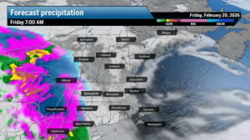
Storm timing, precipitation breakdown and the late-weekend uncertainty
The sequence is driven by a warm front moving east across New England early Friday, which brings a light shield of precipitation while temperatures rise above freezing across Massachusetts, Rhode Island, and Connecticut. Precipitation then intensifies in the afternoon and evening and slowly tapers overnight into Saturday.
- 6 to 8 a. m.: Southwestern Connecticut.
- 8 to 11 a. m.: Western Massachusetts, much of Rhode Island, southern Vermont, and central and eastern Connecticut.
- 11 a. m. to 2 p. m.: Eastern Massachusetts, including Boston, Cape Cod, and the islands; most of New Hampshire and portions of central and northern Vermont.
- 2 p. m. to 5 p. m.: Northern New Hampshire and most of Maine.
Precipitation will intensify through the afternoon and evening before tapering off overnight Friday. A secondary low is expected to form over or near the Gulf of Maine by Friday night and could boost both rain and snow amounts, producing spurts of heavier snowfall where cold air has settled and steadier rain south of the rain-snow line.
Forecasted impacts embedded in the timing: Friday highs are set to reach the mid- to upper-30s, which will keep Boston and areas along the Mass Pike in a wintry mix or cold rain for much of the event. Snow accumulations are expected to be modest in Boston—between 1 and 3 inches by Saturday morning—while northern portions of New England could see higher totals. There will be some minor icing across southern New England away from the coast on Saturday morning. Wind will be negligible with this system.
For the late-weekend or Monday system, models are split: outcomes range from a complete miss to a light brushing. The coastal threat may arrive overnight Sunday or early Monday and has the potential to strengthen into a nor'easter, though most projections keep it as a lighter impact—likely more of a brush than a direct hit.
- Most communities should prepare for evening travel disruptions Friday and targeted plowing needs overnight into Saturday.
- Boston is likely to see a prolonged period of wintry mix before a changeover to snow after dark.
- A secondary low near the Gulf of Maine could concentrate heavier bands and raise totals locally.
- Expect minor icing away from the coast in southern New England Saturday morning; wind impacts are expected to be minimal.
- Late weekend coastal impacts remain uncertain; outcomes span from a miss to a modest nor'easter-style brush early next week.
It's easy to overlook, but the secondary low forming near the Gulf of Maine by Friday night is the feature most likely to push totals upward in localized pockets, especially north of the Mass Pike where colder air is already in place.
If you’re wondering why this keeps coming up, it’s the timing: a daytime period of warmer air will favor mixed precipitation in populated corridors, then a nocturnal cooldown shifts moisture into snow for areas that already sit near or below freezing. That flip is what makes cleanup logistics and evening travel the immediate concern.
Micro timeline (concise):
- Morning-Friday: light precipitation expands east as a warm front lifts through.
- Afternoon–evening Friday: precipitation intensifies across the region; wintry mix persists in southern corridors while north sees accumulating snow.
- Friday night–Saturday morning: changeover to colder conditions with plowable snow in many northern zones; minor icing possible in southern inland spots.
Final note: preparations should focus on evening travel plans Friday and readiness for overnight snow removal; details on the coastal system for late weekend into Monday may evolve.