


Tornado Warnings: Chance Of Severe Storms Rising Across Ohio Valley; Threat Persists Through 9 PM ET
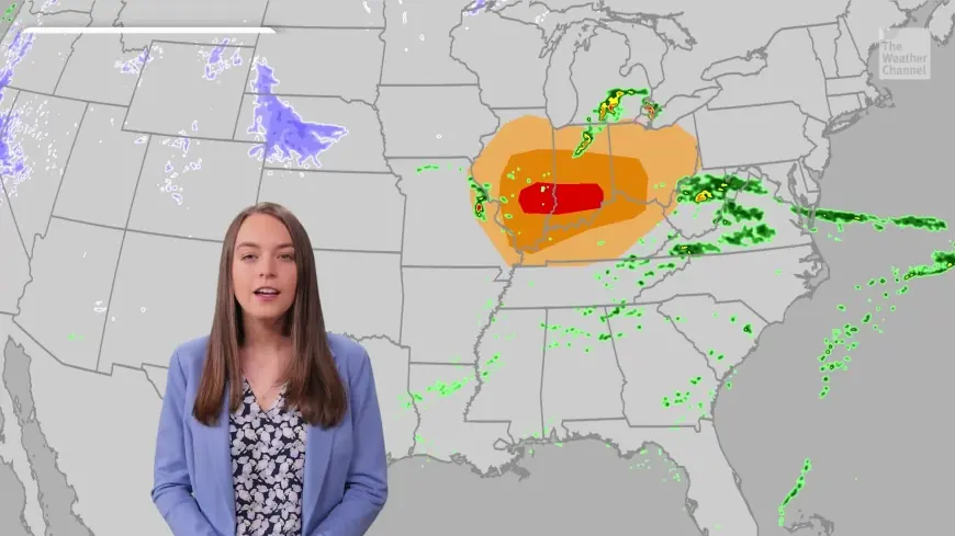
Tornado warnings are central to the evolving forecast as the chance of severe storms and tornadoes rises across the Ohio Valley. The tornado threat continues for Indiana and North Central Kentucky through about 9 PM ET tonight, with a transition toward a more marginally severe storm setup for Kentucky through about midnight ET.
Tornado Warnings: What happened and what’s new
An update flagged an increasing chance of severe storms and tornadoes across the Ohio Valley ahead of tonight’s active period. The tornado threat is centered on Indiana and North Central Kentucky and is expected to persist through about 9 PM ET; afterward, conditions in Kentucky could shift to a marginally severe storm situation through about midnight ET.
Forecasters expect scattered thunderstorms in the region this afternoon and evening, and some of those storms could be strong. The evolving line of storms and instability is the immediate driver of the heightened severe-weather outlook for the area this evening.
Behind the headline
Context: The short-term pattern is set up to produce an evening window of severe weather for parts of the Ohio Valley. The immediate threat this evening is described as focused on tornadoes and other severe hazards, then shifting to a lower-severity storm environment for Kentucky later in the night.
Forecast progression: Cooler, breezy conditions are expected on Friday with highs in the 40s and 50s and at least some sunshine. A brief morning sprinkle is possible Friday north of I-64. Colder air moving into the region will increase the chance of spotty rain or snow showers late Friday night. An early rain/snow mix is possible Saturday but is not expected to cause major travel issues because temperatures should remain just above freezing and the ground is expected to be warm.
Weekend and next-week trajectory: Some clearing is possible Saturday afternoon though a small shower chance will remain. Scattered snow showers are expected Sunday and Monday as a large coastal system strengthens off the Atlantic. More seasonable air and calmer weather are forecast to return by Tuesday, while rain chances are projected to rise again in the middle to late portion of next week.
Stakeholders: Residents and travelers in the Ohio Valley this evening and into the weekend are the most directly affected. Local officials, emergency managers and transportation planners will be watching the timing and intensity of storms because of the potential for damaging winds, tornadoes and impacts to travel.
What we still don't know:
- Exact locations and timing of any tornadoes or where the strongest storms will develop.
- Whether individual thunderstorms will intensify fast enough to produce significant, long-track tornadoes.
- How the timing of the cold air arrival will affect precipitation type and the extent of any snow showers late Friday into Monday.
What happens next
- Evening severe window: The tornado threat remains active through about 9 PM ET for Indiana and North Central Kentucky; after that, Kentucky could see a transition to a marginally severe storm environment through about midnight ET. Trigger: persistence of instability and storm organization into the evening hours.
- Friday cooldown and spotty precipitation: Cooler, breezy conditions with highs in the 40s and 50s and a possible brief sprinkle Friday morning north of I-64. Trigger: arrival of cooler air shown in the forecast.
- Late Friday night changeover: Spotty rain or snow showers may develop as colder air moves in late Friday night. Trigger: the timing and depth of colder air into the region.
- Saturday mix but minimal travel impacts: An early rain/snow mix could occur Saturday but is not expected to cause major travel problems because temperatures are forecast just above freezing and the ground is warm. Trigger: morning precipitation timing and surface temperatures.
- Coastal system and weekend snow chance: Scattered snow showers are forecast Sunday and Monday as a large system strengthens off the Atlantic; calmer, more seasonable conditions are expected by Tuesday. Trigger: the strength and track of the coastal system.
- Rising rain chances later next week: Expect an uptick in rain chances in the mid to late portion of next week. Trigger: the next broad-scale system moving into the region.
Why it matters: The immediate concern is public safety during the evening severe window, particularly for people in the warning area who may be exposed to strong thunderstorms or tornadoes. The broader sequence of colder air and coastal development will affect precipitation type and travel through the weekend and early next week. Near-term planning for travel and outdoor activities should account for the potential for strong storms tonight and mixed precipitation risks into Saturday and beyond.